Balabac: How a Forgotten Philippine Island Became the Frontline of a Superpower Showdown
A strategic dissection of the Balabac Strait — the chokepoint where U.S. basing rights, Chinese naval transits, and a new Philippine legal architecture are reshaping the balance of power in the South China Sea.
Indo-Pacific Report | Strategic Analysis Desk | April 2026
Introduction: The Island That Stopped Being Forgotten
There is an island at the southwestern edge of the Philippines that most Filipinos have never visited. Most could not locate it on a map. It sits so far south that the Malaysian coastline is closer than Manila. For decades, its identity was defined by a single word: forgotten.
That identity no longer applies.
On this island, construction crews are laying the foundations of a three-kilometre military runway. Warehouses, barracks, and command structures are rising out of the forest. Some of what is being built has not been disclosed publicly — and, according to Philippine defence officials, never will be. American forces, though rarely visible to the naked eye, are embedded in the planning of every major decision.
The island is called Balabac. And what is unfolding there is not a local infrastructure project. It is an opening move in a strategic contest running between Washington, Beijing, and Manila — a contest playing out over a narrow strip of water that very few outside the region have heard of, but that carries disproportionate weight over the future of the South China Sea.
Geography as Destiny: Why Balabac Matters
To understand the significance of Balabac, one must begin with its geography — because geography, here, is the argument.
Balabac lies at the absolute southwestern tip of Palawan, the long, narrow Philippine province often described as the country’s last ecological frontier. If Palawan resembles a finger pointing toward Borneo, Balabac is the fingertip. Just across a strait no more than 50 kilometres wide, the Malaysian coast begins. To the west lies the South China Sea. To the east, the Sulu Sea.
For any warship seeking to move between the South China Sea and the Sulu Sea without detouring hundreds of kilometres around the archipelago, there are only a handful of viable passages. The Balabac
Strait is one of them. In military terminology, it is a chokepoint — and chokepoints, throughout naval history, are where control of the sea is contested and decided.
This is the geography that transformed Balabac from a quiet Philippine periphery into a strategic asset of national and international consequence.
The Warships in the Water: China’s Quiet Transit Pattern
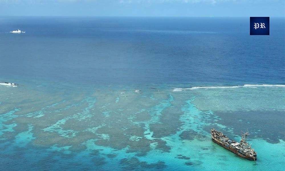
Since at least 2019, the pattern has been unmistakable. Chinese warships — not fishing boats, not coast guard cutters, but frontline People’s Liberation Army Navy (PLAN) combatants — have repeatedly transited through the Balabac Strait, often without notifying Philippine authorities.
Between February and August 2019 alone, at least 14 Chinese warships were documented moving through Philippine archipelagic waters via this corridor. Many switched off their Automatic Identification System (AIS) transponders — the very electronic beacons that allow coastal states to monitor vessel movements. Some refused to identify themselves when challenged by Philippine Navy ships. In one documented case, a Chinese aircraft carrier itself transited Philippine archipelagic waters using the Balabac Strait–Sibutu Passage route.
The pattern persisted. In June 2024, the Armed Forces of the Philippines (AFP) confirmed that four PLA Navy vessels — two destroyers, a frigate, and a replenishment oiler — were detected moving through the Balabac Strait. The Philippine military challenged them. The Chinese ships responded, but the operational message was consistent: Beijing treats this waterway as a corridor it may use at will.
The asymmetry was stark. For years, the Philippines possessed limited means to contest these movements. Balabac was remote and underfunded. The nearest major military facility was far to the north in Puerto Princesa. A small naval outpost — Naval Station Narciso del Rosario — existed on the island, but without a runway, without meaningful surveillance capability, and without a credible deterrent.
In strategic terms, presence is the currency of sovereignty. And for decades, in Balabac, Manila simply was not present.
EDCA and the Pivot: The Agreement That Reopened the Door
To understand the transformation now underway on Balabac, one must understand four letters: EDCA.
The Enhanced Defense Cooperation Agreement, signed in 2014 between the Philippines and the United States, is not a basing treaty. EDCA does not restore permanent U.S. bases on Philippine soil — a politically charged arrangement that ended with the closure of Clark Air Base and Subic Bay Naval Base in the early 1990s. What EDCA does is permit American forces to rotate through designated Philippine military installations on a temporary basis, preposition equipment, build approved facilities, and conduct joint exercises. Sovereignty and ultimate control remain with Manila.
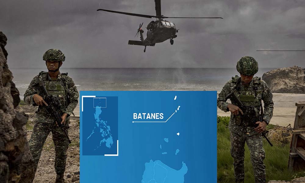
Under President Benigno Aquino III, five original EDCA sites were designated: Basa Air Base in Pampanga, Fort Magsaysay in Nueva Ecija, Antonio Bautista Air Base in Palawan, Mactan–Benito Ebuen Air Base in Cebu, and Lumbia Air Base in Cagayan de Oro.
In April 2023, President Ferdinand Marcos Jr. approved four additional sites, bringing the total to nine. Three of the new sites — Naval Base Camilo Osias and Lal-lo Airport in Cagayan, and Camp Melchor Dela Cruz in Isabela — lie in the northern Philippines, positioned toward Taiwan and the Luzon Strait. They face a different strategic direction.
The fourth was Balabac.
The detail that matters most, and that is rarely emphasised in mainstream coverage, is this: Balabac is the only EDCA site directly adjacent to the South China Sea.
The implication follows directly. Balabac is not oriented toward Taiwan contingencies. It is oriented toward the contested waters where Chinese and Philippine vessels clash almost daily, and it sits directly astride the chokepoint Chinese warships have been using for years. That positioning is not a coincidence of geography. It is a statement of intent.
General Andres Centino, then AFP Chief of Staff, inspected the island in May 2023 and publicly described it as “very strategic,” emphasising the need to detect foreign and friendly vessels transiting between the South China Sea and the Sulu Sea. The infrastructure plan confirms that logic. The three-kilometre dual-use runway — construction began in 2019 under a partnership between the Department of National Defense and the Department of Public Works — is explicitly designed to host surveillance aircraft capable of monitoring the strait. Beyond the runway, plans include a command and control building, a humanitarian assistance and disaster relief warehouse, new barracks, and significant upgrades to Naval Station Narciso del Rosario, including a new beaching ramp and pier.

And there are the structures Philippine defence officials have said will never be disclosed publicly — a deliberate opacity that is itself a signal.
American forces, for their part, are already embedded in the operational planning. Joint exercises, shared intelligence flows, and rotational deployments form the quiet connective tissue of the new EDCA architecture. The U.S. footprint on Balabac may not be visible to the casual observer — but it is woven into the posture of the base itself.
The Legal Weapon: Rewriting the Map
Manila has not confined itself to physical construction. It has simultaneously moved to rewrite the legal architecture of its maritime domain — and Balabac sits at the centre of that transformation as well.
On 8 November 2024, President Marcos signed into law two landmark pieces of legislation: the Philippine Maritime Zones Act and the Philippine Archipelagic Sea Lanes Act (Republic Act 12065).
The Maritime Zones Act formally defines the Philippines’ internal waters, archipelagic waters, territorial sea, contiguous zone, exclusive economic zone, and continental shelf, in full compliance with the United Nations Convention on the Law of the Sea (UNCLOS). This matters because for decades — even after the 2016 arbitral ruling by the Permanent Court of Arbitration at The Hague, which rejected China’s expansive nine-dash line claims — Manila had never codified its maritime boundaries into domestic law. The gap between international legal victory and domestic legal enforcement is now closed.
The Archipelagic Sea Lanes Act goes further. It designates exactly three sea lanes through which foreign military vessels and aircraft may exercise passage through Philippine archipelagic waters. One of those three lanes runs directly through the Balabac Strait: Celebes Sea Basilan Strait Sulu Sea
Nasubata Channel Balabac Strait South China Sea.
EDCA Is Not a U.S. Base: Manila’s Strategic Recalibration Amid Middle East Tensions
Outside these three corridors, foreign warships are now restricted to innocent passage — a considerably narrower right under international law. Innocent passage prohibits lingering, forbids weapons exercises, and can, under certain conditions, be suspended by the coastal state for national security reasons.
The strategic implications are substantial. Previously, Chinese warships could argue that their movements followed customary routes through Philippine waters. After November 2024, Manila possesses firm legal grounds to restrict, regulate, and formally challenge any transit that falls outside the three designated sea lanes.
Beijing’s reaction was swift. Within hours of Marcos signing the laws, the Chinese foreign ministry summoned the Philippine ambassador to lodge a “stern protest.” Manila did not retreat. Marcos framed the legislation as a demonstration of the Philippines’ commitment to a rules-based international order. Senator Francis Tolentino, who championed the bill, argued that even if China refuses to recognise the laws, the endorsement of the broader international community strengthens Manila’s position.
The transformation is now complete. Balabac is no longer merely a geographic chokepoint. It is a legally fortified chokepoint — a location where Philippine sovereignty is asserted both physically, through infrastructure, and legally, through domestic statute grounded in international law.
The Wider Theatre: The South China Sea Contest
Balabac cannot be understood in isolation. It is one node in a contested maritime system that now carries more than three trillion U.S. dollars in annual trade — a waterway claimed, in overlapping fashion, by China, the Philippines, Vietnam, Malaysia, Brunei, and Taiwan.
China’s claims are the most expansive and the most contested. Beijing asserts sovereignty over nearly the entire sea under its nine-dash line — the same claim the Permanent Court of Arbitration ruled in 2016 has no legal basis under international law. China rejected the ruling. And since then, it has escalated, rather than softened, its posture.
Artificial islands have been constructed and militarised. Missile systems have been deployed. Airstrips have been laid down on reefs that were underwater a decade ago. The Chinese Coast Guard and maritime militia have exerted constant pressure on Philippine vessels — using water cannons, blocking resupply missions, and in a particularly alarming incident in March 2026, aiming fire-control radar at a Philippine naval vessel near Sabina Shoal.
This is the signature pattern of what analysts call gray-zone warfare: not open conflict, but not peace either. A sustained, incremental squeeze designed to establish control without ever crossing the threshold that would trigger a military response from the United States or its treaty partners.
This is precisely the strategic environment in which Balabac becomes pivotal. China views the EDCA expansion — particularly the sites in Palawan and the northern Philippines — as a direct challenge. Huang Xilian, a former Chinese ambassador to Manila, publicly warned that Washington intends to use the new EDCA sites to interfere in the Taiwan Strait and advance an anti-China agenda at the expense of Philippine development.
Beijing’s concern, from its own strategic vantage point, is not unfounded. A military runway on Balabac capable of hosting surveillance aircraft means the Philippines — and by extension the United States — can now monitor Chinese naval movements through the strait in real time. Combined with the Archipelagic Sea Lanes Act, Manila now possesses both the legal authority and the physical capability to challenge Chinese transits that do not conform to Philippine regulation.
“For Beijing, Balabac is not another Philippine military project. It is a door closing on a corridor China has used freely for years.”
The Human Dimension: The People of Balabac
In any serious geopolitical analysis, it is easy to lose sight of the human terrain on which strategy unfolds. Balabac is not merely a chokepoint on a planner’s map. It is home to a community that has spent decades at the edge of national attention, asking for the basic architecture of modern life — functioning electricity, paved roads, fully staffed schools, and pathways for their children that do not require leaving the island.
For residents of Balabac, the military buildup carries a cautious hope. Construction projects mean jobs. A runway means connectivity. Base infrastructure means an economic footprint in a place where, until recently, there was very little of one.
But the transformation also carries risk. Every strategic chokepoint is somebody’s fishing ground. Every new military installation sits on somebody’s home. The long-term test of the Balabac project is not only whether it succeeds in deterring Chinese naval transits or tightening the U.S.–Philippines alliance. It is whether the residents of Balabac — who did not choose this strategic role — benefit from the transformation of their island, or are marginalised by it.
That distinction will ultimately shape how sustainable the posture is, politically, at home.

Strategic Outlook: What Balabac Signals for the Indo-Pacific
Balabac is a small island. But what is happening on it carries significance far out of proportion to its size. Four strategic conclusions follow from the analysis above.
First, the era of Philippine strategic hesitation is ending. For years, Manila oscillated between accommodation and assertion in its approach to Beijing. Under Marcos, that ambiguity has narrowed sharply. The expansion of EDCA to nine sites, the passage of the Maritime Zones and Archipelagic Sea Lanes Acts, and the deliberate selection of Balabac as the only EDCA site directly facing the South China Sea together signal a posture that combines alliance deepening with legal codification.
Second, U.S.–China competition in Southeast Asia is increasingly being fought through infrastructure, law, and posture rather than declared policy. There is no treaty moment, no diplomatic confrontation, no single announcement that captures the magnitude of the shift unfolding on Balabac. Instead, the contest is moving through runway construction, sea-lane designations, surveillance architecture, and rotational deployments. This is the texture of twenty-first-century great-power rivalry.
Third, chokepoints are re-emerging as decisive geography. For much of the post–Cold War era, strategists treated maritime chokepoints as secondary features of a globalised trade system that would remain open by default. That assumption no longer holds. The Balabac Strait, the Luzon Strait, the Malacca Strait, the Bab-el-Mandeb, the Strait of Hormuz — all are returning to the strategic foreground. Control over narrow waters is once again determining influence over broad regions.
Fourth, the legal dimension of sovereignty is becoming as important as the physical dimension. By codifying its maritime zones and designating specific sea lanes through domestic legislation, the Philippines has built something that infrastructure alone cannot provide: a juridical basis for contesting future transits. This is a lesson other Southeast Asian states are studying closely.
The contest over Balabac will not be resolved quickly. China will not accept the new Philippine legal architecture. The United States will continue to deepen its rotational presence. Manila will continue to build — and will continue to be tested in the grey zone.
But the trajectory is now visible. A forgotten island at the southern edge of the Philippines has become one of the most strategically consequential points on the Indo-Pacific map. And the story of how that happened — and what it means — is only beginning.
Indo-Pacific Report provides strategic analysis on Indo-Pacific geopolitics, maritime security, and great-power competition in the world’s most contested region.
Visit us at www.indopacificreport.com.