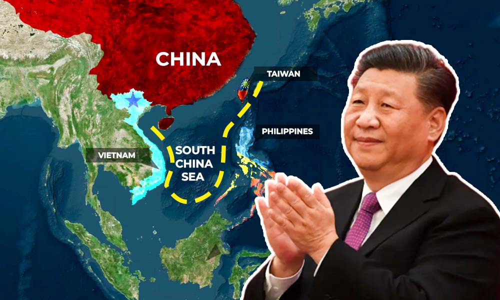
The South China Sea’s new ten-Dash Line, transformed from the nine-dash line, which was first delineated on a Chinese map in 1947, has emerged as a central and contentious element in global geopolitical dialogues. In July 2016, an international tribunal, the Permanent Court of Arbitration in The Hague, delivered a landmark ruling, declaring that China’s use of the Nine-Dash Line to assert historical rights over the South China Sea had no legal basis. Despite this judgment, China maintained its territorial claims, further intensifying regional tensions. The Nine-Dash Line’s scope covers a wide expanse, including various islands, shoals, and reefs claimed by multiple nations. The line’s deliberate ambiguity has complicated discussions surrounding sovereignty and maritime rights in the South China Sea, leading to ongoing disputes and diplomatic challenges. China’s recent publication of a new national map featuring a “10-dash line” has reignited concerns and raised questions about the region’s future.
Defining the Nine-Dash Line
The nine-dash line, sometimes referred to as the eleven-dash line by Taiwan, has been a source of ongoing tension and disputes in the South China Sea. It represents a set of line segments on various maps used to assert the territorial claims by the People’s Republic of China (PRC) in the South China Sea. The contested area encompasses a vast expanse, including the Paracel Islands, the Spratly Islands, the Pratas Island, the Macclesfield Bank, the Scarborough Shoal, and the Vereker Banks. These territories have been subject to land reclamation efforts by various countries, including China, Taiwan, and Vietnam. The nine-dash line’s ambiguity continues to be a source of concern and a focal point in discussions surrounding sovereignty and maritime rights in the South China Sea.
China’s Stance and Actions
The history of the nine-dash line is intricate, with its evolution spanning several decades. It was originally introduced as an eleven-dash line in a map published by the Republic of China in 1947. However, in 1952, two dashes were removed from the Gulf of Tonkin, seen as a diplomatic concession to North Vietnam. This transformation in the line, initially consisting of eleven dashes, was influenced by political shifts and goodwill gestures, notably Chairman Mao Zedong’s decision to relinquish claims in the Gulf of Tonkin. This highlights how diplomacy played a pivotal role in shaping the line and underscores its adaptability in response to changing diplomatic relations, leading to tensions and disputes with neighboring countries such as Vietnam, the Philippines, Brunei, Indonesia, and Malaysia.
This maritime boundary, spanning decades, illustrates the malleability of geopolitical boundaries when influenced by diplomatic gestures and changing political dynamics, demonstrating the intricacies and multifaceted nature of disputes in the South China Sea.
A Glimpse of Evolving South China Sea Demarcations
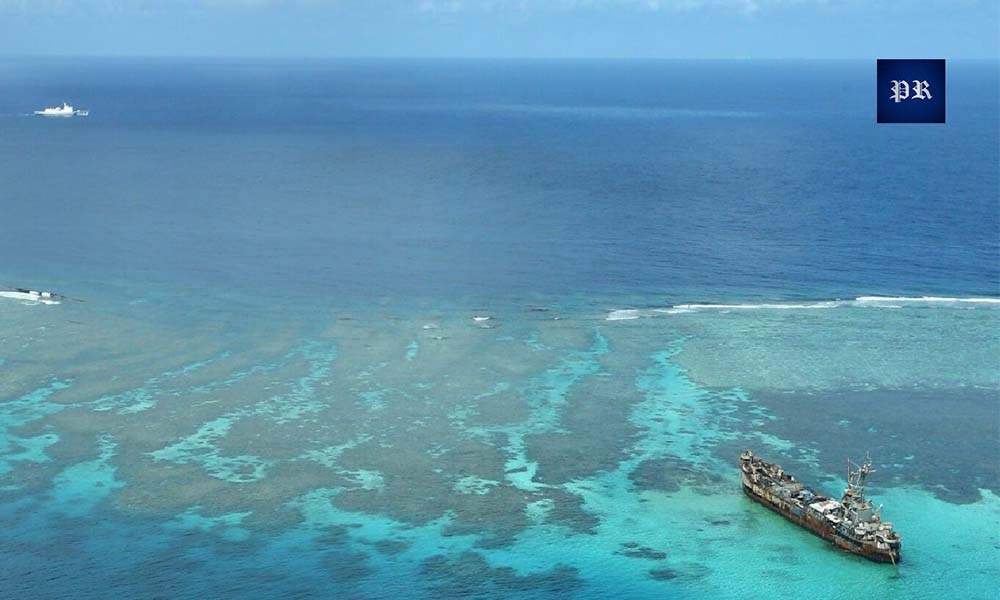
The recent history of the South China Sea has seen a series of critical events and disputes among the claimant states. Let’s get back to January 19, 1974, when Chinese forces seized the Paracel Islands from South Vietnam. Subsequent confrontations include a clash between Chinese and Vietnamese naval forces in March 1988, after China’s occupation of Fiery Cross and Cuarteron reefs in the Spratlys, leading to casualties among Vietnamese sailors. The year 1994 marked a significant development when the United Nations Convention on the Law of the Sea (UNCLOS) came into effect, establishing a legal framework for maritime jurisdiction, including territorial seas, exclusive economic zones, and continental shelves. In 1995, China’s navy occupied Mischief Reef, leading to skirmishes with Philippine naval forces. The year 2002 witnessed an agreement between ASEAN member states and China on the non-binding Declaration on the Conduct of Parties in the South China Sea, with the intent to create a Code of Conduct. In May 2009, China submitted the “nine-dash line” map in response to a joint submission by Malaysia and Vietnam, raising further concerns.
The situation escalated in April 2012, when China asserted control over Scarborough Shoal, following a standoff prompted by the Philippine Navy’s attempt to arrest Chinese fishermen. The Philippines initiated an arbitration case under UNCLOS in January 2013 to challenge Chinese claims, and China commenced land reclamation and construction on several features in the Spratlys in late 2013. In May 2014, Vietnamese and Chinese vessels collided as Vietnam tried to prevent the placement of a Chinese oil rig in disputed waters. The United States started freedom of navigation operations, in the South China Sea in October 2015. A significant milestone occurred on July 12, 2016, when an arbitral tribunal in The Hague, found that China’s nine-dash line had no legal basis under UNCLOS. In July 2018, China and ASEAN agreed on a Single Draft Negotiating Text for the Code of Conduct. A notable standoff began in December 2019, involving China, Malaysia, and Vietnam over the deployment of a Malaysian drillship. More recently, in March 2021, the Philippines demanded the withdrawal of around 200 Chinese vessels, including suspected maritime militia boats, from waters around Whitsun Reef in the Spratlys.
The 2016 International Tribunal Ruling
On July 12, 2016, a significant turning point was reached in the ongoing dispute surrounding the Nine-Dash Line when an international tribunal, known as the Permanent Court of Arbitration in the Hague, issued a landmark ruling. This tribunal unequivocally declared that the Nine-Dash Line lacked any “legal basis” for making historical claims to the South China Sea—a body of water that had been claimed, in part, by six different governments. This verdict stood as a pivotal moment, emphasizing the critical importance of adhering to international law when settling territorial disputes and significantly challenging China’s maritime ambitions.
In the wake of the tribunal’s verdict, Beijing responded with a complex blend of indignation and obstinacy, vehemently challenging the tribunal’s jurisdiction and declining to acknowledge the ramifications of the judgment. China persisted in asserting its dominion over the South China Sea, especially in regions that overlapped with territorial assertions proffered by neighboring nations like the Philippines, Vietnam, and Malaysia. This sequence of events accentuated the intricate interplay between global legal norms and domestic interests in the enduring dispute pertaining to the Nine-Dash Line, a conundrum that continues to stoke regional frictions within the South China Sea.
Evolution of the 10-Dash Line
China’s publication of a new national map, featured in ‘China’s 2023 Ministry of Natural Resources map’, has once again sparked strong reactions from countries disputing its validity. The move has captured the attention of observers, sparking debates and concerns in Southeast Asia and beyond. While the appearance of the tenth dash line isn’t entirely novel, its reintegration with the original nine-dash line on the latest map holds symbolic and geopolitical implications. This development not only reaffirms China’s ambitious territorial claims, but also raises important questions about China’s regional intentions.
One of the key ramifications of this map is its impact on cross-strait relations, particularly concerning Taiwan. The inclusion of the tenth dash line on the map serves to symbolically subsume Taiwan’s territorial claims in the South China Sea, aligning Taipei more closely with Beijing’s nationalist agenda. The new map has also captured the attention of countries further south, as it denotes the dash line as a “national boundary,” using shading that extends from the nine-dashed lines within the South China Sea. This visual effect seems to project China’s territorial claims closer to the coastlines of the Philippines, Malaysia, Brunei and Vietnam. While these claims aren’t substantively altered from previous Chinese maps, the ambiguity of the dash line’s status remains concerning for neighboring nations. Amid this uncertainty, Indonesia, for example, may find its sensitivities in the South China Sea reignited as the tenth dash bisects Indonesia’s gas-rich Exclusive Economic Zone off the Natuna’s coast, potentially reopening issues that Jakarta had believed were resolved through earlier bilateral assurances.
As a result, even though the claims in the South China Sea aren’t the foremost concern for all Southeast Asian nations, China’s evolving approach continues to elicit a sense of disquiet among regional nations and global observers alike. It’s imperative to underline that maps, in and of themselves, do not carry any inherent legal authority as per the United Nations Convention on the Law of the Sea (UNCLOS). Consequently, China’s paramount challenge lies in the imperative to align its South China Sea assertions with the framework of international law. This matter has been gaining escalating global attention, particularly in light of the amplified scrutiny directed at the contested islands, coral formations, and rocky outcrops within the region.
Changing Maps and Ambiguities
China’s recent publication of a new map, known as the ’10-dash line,’ asserting territorial claims over much of the South China Sea, has escalated regional tensions and challenged the rules-based international order. This move disregards the 2016 international court ruling against China’s ‘nine-dash line’ claims and has raised concerns among ASEAN states and India. The timing, coinciding with India hosting the G20 summit, underlines China’s disregard for diplomatic resolution.
This could lead to regional security challenges and necessitate collective responses to address China’s unilateral behavior. It places China’s actions in a broader context of international diplomacy, prompting a reevaluation of diplomatic relations and a consideration of how these disputes may impact countries beyond the immediate region. This map has now made China’s intentions even more transparent, with significant consequences at regional and global realms.
Cultural and Diplomatic Entanglements
China’s “nine-dash line,” a symbol of its claims over the South China Sea, has inadvertently found its way into global popular culture, triggering political disputes and diplomatic entanglements. Recent examples include Vietnam’s ban of the film “Uncharted” due to a controversial scene featuring the nine-dash line and the Philippines’ protests against Netflix’s series “Pine Gap” for its depiction of the line, leading to the series removal from distribution setups.
While it serves to illustrate China’s South China Sea claims, the Chinese Communist Party has never explicitly defined its precise meaning, leaving international observers, legal scholars, and analysts to decipher its implications. Some see it as a maritime border, while moderate legal scholars argue for sovereignty and rights within UNCLOS boundaries. Nevertheless, concerns linger about its potential to signal Beijing’s broader territorial ambitions, including areas not subject to sovereign appropriation.
Beyond popular culture, the nine-dash line has been featured in various forms, including ESPN’s televised map and Chinese e-passports, which were declined by the Philippines and Vietnam. Its role in popular media has added to the contentious narrative of maritime territorialization, reinforcing sovereignty over maritime territories. While the contentious line remains disputed and its compatibility with international law is under scrutiny, the South China Sea conflict continues to involve complex legal challenges, diplomatic efforts, and military activities, with no resolution in sight. These ongoing tensions emphasize the multifaceted nature of the dispute, reflecting its status as a global concern, as nations strive to assert their maritime rights and address conflicting claims.