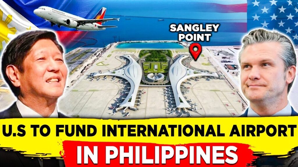
U.S. Funds Sangley Point Airport Study Near the South China Sea
The United States just announced something that looks simple. On paper, it is just an airport.
But many analysts believe it is far more than that.
This week, the US Trade and Development Agency confirmed that it will fund a feasibility study for a new international airport in the Philippines. The location is Sangley Point. The site sits in Cavite, just outside Manila Bay.
For most travelers, this is good news. Manila’s main airport is one of the most crowded in Asia. A second international airport would ease the pressure. It would create jobs. It would bring more direct flights from the United States.
But there is another story here. A deeper one. Because Sangley Point is not just any patch of land. It was once a US naval base. Geography made it valuable then. And geography is making it valuable again now.
This is the story of why a quiet airport project in the Philippines may shape the future of the South China Sea, the Taiwan question, and the long contest between America and China.
What Sangley Point really is
Sangley Point is a small peninsula. It sits at the mouth of Manila Bay. It is around ten kilometers west of Ninoy Aquino International Airport, the country’s main hub.
Most people have never heard of it. But for the US Navy, it was once a crown jewel. The Americans used Sangley Point during World War II. They used it during the Cold War. They used it during the Vietnam War. Maritime patrol planes flew out of its runway. Communications towers tracked enemy movements. The base was a window into the South China Sea.
In 1971, the US handed it back to the Philippines. Today, it hosts the Philippine Navy and the Philippine Air Force’s 15th Strike Wing.
But here is the key point. The geography never changed. From Sangley Point, you can reach Manila Bay in minutes. You can reach the West Philippine Sea, the disputed waters where China and the Philippines clash, in hours. And further north sits the Luzon Strait — the narrow body of water that connects Taiwan to the rest of the world.
Geography, as the strategist Robert Kaplan often reminds us, does not move. It only waits.
https://indopacificreport.com/how-drones-just-changed-the-biggest-us-philippine-war-games/
The new airport project
Now, in May 2026, the story enters a new chapter.
The US Trade and Development Agency, known as USTDA, has agreed to fund a feasibility study for the proposed Sangley Point International Airport. The grant goes to a Philippine developer called Cavitex Holdings. They have selected a California-based firm called The S-A-P Group to carry out the study.
The study will look at air traffic forecasts. It will analyze the finances. And it will recommend advanced security screening. That last detail matters. The new airport is being designed for direct flights to major American cities. So the security must meet US standards.
The numbers behind this are massive. Manila’s main airport handled around 52 million passengers in 2025. That is far above its safe capacity. A new airport at Sangley Point would ease the pressure, create tens of thousands of jobs, and unlock billions of dollars in long-term economic activity.
Then came a key line from the USTDA’s deputy director, Thomas Hardy. He said this project supports a collective goal of a free and open Indo-Pacific.
That phrase is not casual. It is the core language of US strategy in Asia. Whenever Washington uses it, you can be sure the project is about more than business.
Why analysts are paying attention
This is where civilian airports begin to look like something else.
Modern military thinking has changed. The age of giant overseas bases is fading. What countries want now is access. They want flexibility. They want infrastructure that can be used in peacetime and quickly turned into support during a crisis.
This idea has a name. It is called dual-use infrastructure.
A civilian airport can host commercial flights today. But during a crisis, it can also support troop movement, surveillance flights, humanitarian airlifts, evacuation operations, and supply runs.
Joshua Espena, a Manila-based security analyst, has argued that modern warfare runs on agility and decentralized logistics. Flexible infrastructure, he says, is now the center of gravity. Another expert, Arnaud Leveau, has pointed out that modern airports today carry strategic value far beyond their civilian role.
China has known this for years. Under its Belt and Road Initiative, Beijing has built airports, ports, and roads across Asia and the Pacific. Many of these projects look civilian on the outside. But researchers have called this network a force multiplier — useful in peace and even more useful in war. Washington has watched and learned.
The power of location
Now look at the map. This is where Sangley Point shines.
According to Filipino analyst Justin Kyle Malarayap, Sangley Point has unique advantages. It offers faster access to Manila Bay than any other airport. It already has naval and air force infrastructure next door. And it provides better maritime coverage of the western Philippines than Clark or Subic — the older US bases further north.
In simple terms, when something happens at sea, response time matters. And Sangley Point sits closer to the action than almost anywhere else.
The action, in this case, is not hypothetical. China’s coast guard and maritime militia have clashed repeatedly with Philippine vessels near Second Thomas Shoal and Scarborough Shoal. Water cannons, lasers, and ramming have become routine. Philippine forces increasingly need quick logistics, quick air support, and quick command coordination.
A modern airport at Sangley Point gives them all three.
https://www.youtube.com/watch?v=Z0PcqU0cSDE
The Taiwan factor
There is one more piece. The Luzon Strait.
This narrow body of water sits between Taiwan and the northern Philippines. It is one of the most important waterways in the entire Indo-Pacific. Any future crisis involving Taiwan would touch this strait. Submarines, warships, and aircraft would all need to pass through it.
The United States has been quietly preparing. Under the Enhanced Defense Cooperation Agreement, Washington has gained access to new sites across the Philippines, including bases pointed toward Taiwan. Sangley Point fits into the same logic. It does not need to be a base. It only needs to be ready.
This is the heart of modern deterrence. As John Mearsheimer has long argued, great powers do not stumble into competition. They prepare for it, step by step, by securing access, logistics, and geography long before any crisis begins.
Philippines Opens New Luzon Strait Base to Bolster Deterrence Against China
The China angle
Here is the twist that makes this story even sharper.
A few years ago, Sangley Point was on a very different track. The original airport deal was led by a Chinese state-owned company called China Communications Construction Company, or CCCC.
Then everything changed. In 2021, the Philippine government cancelled the deal, citing deficiencies in the developer’s documents. Around the same time, the US blacklisted CCCC for its role in building China’s artificial islands in the South China Sea — the very islands that today threaten Philippine fishermen and naval ships.
The Philippine Navy at the time was vocal. Senior officers warned that handing such a strategic site to a Chinese state company was a national security risk. Vice Admiral Giovanni Bacordo, then the Navy chief, said the service wanted to stay at Sangley Point to ensure there were no security violations.
Now, five years later, the same site is being studied by an American firm with US government funding. The shift is more than commercial. It is geopolitical. It is symbolic. The competition over Asian infrastructure has a new front line — and that front line runs through Manila Bay.
The Philippine balancing act
Manila’s position in all this is delicate.
The Philippines is modernizing fast. It is buying ships, missiles, and aircraft. It is deepening defense ties with the United States, Japan, Australia, Canada, and the United Kingdom. The Luzon Economic Corridor, which includes Sangley Point, is itself a multi-country project — connecting Subic Bay, Clark, Manila, and Batangas, and involving ten partner countries.
But Philippine leaders also want to avoid framing every project as anti-China. So the official language is about jobs, connectivity, and resilience. The strategic value is real, but it is wrapped in the language of development.
This is classic small-state diplomacy. Take the help. Stay flexible. Avoid the spotlight when you can.
The risks
But dual-use infrastructure comes with a cost.
Espena and other analysts have warned that civilian assets become more exposed when they take on strategic value. Supply chains can be disrupted. Cyber attacks can target airports. And in a crisis, an airport built for tourists can become a target for missiles.
This is the paradox of the new era. The more useful an airport becomes for defense, the more vulnerable it becomes too.
The return of strategic geography

So what does it all mean?
It means that the airport at Sangley Point is not just an airport. It is a sign of how power works today.
In the past, great powers built empires through colonies and warships. In the twentieth century, they built giant overseas bases. In our century, they build airports, ports, and logistics hubs that look ordinary on the outside but carry strategic value underneath.
Sangley Point is one such hub. Its location offers access to Manila Bay, the West Philippine Sea, and the Luzon Strait. Its history ties it to the US Navy. And its future, increasingly, ties it to the contest between America and China.
The Philippines may call it an airport. The US may call it connectivity. But geography is honest. And geography says this place matters.
The battle for the Indo-Pacific will not be decided only by warships and missiles. It will be decided by who controls the airports, the harbors, the supply lines, and the simple stretches of land that quietly shape the balance of power.
Sangley Point looks like an airport.
In the new map of Asia, it is much more than that.