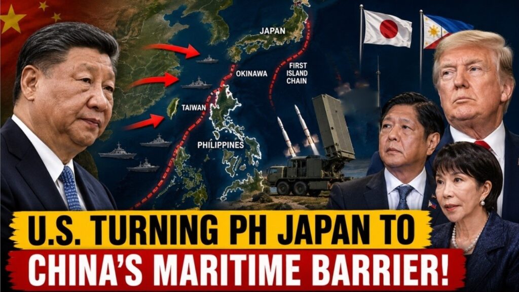
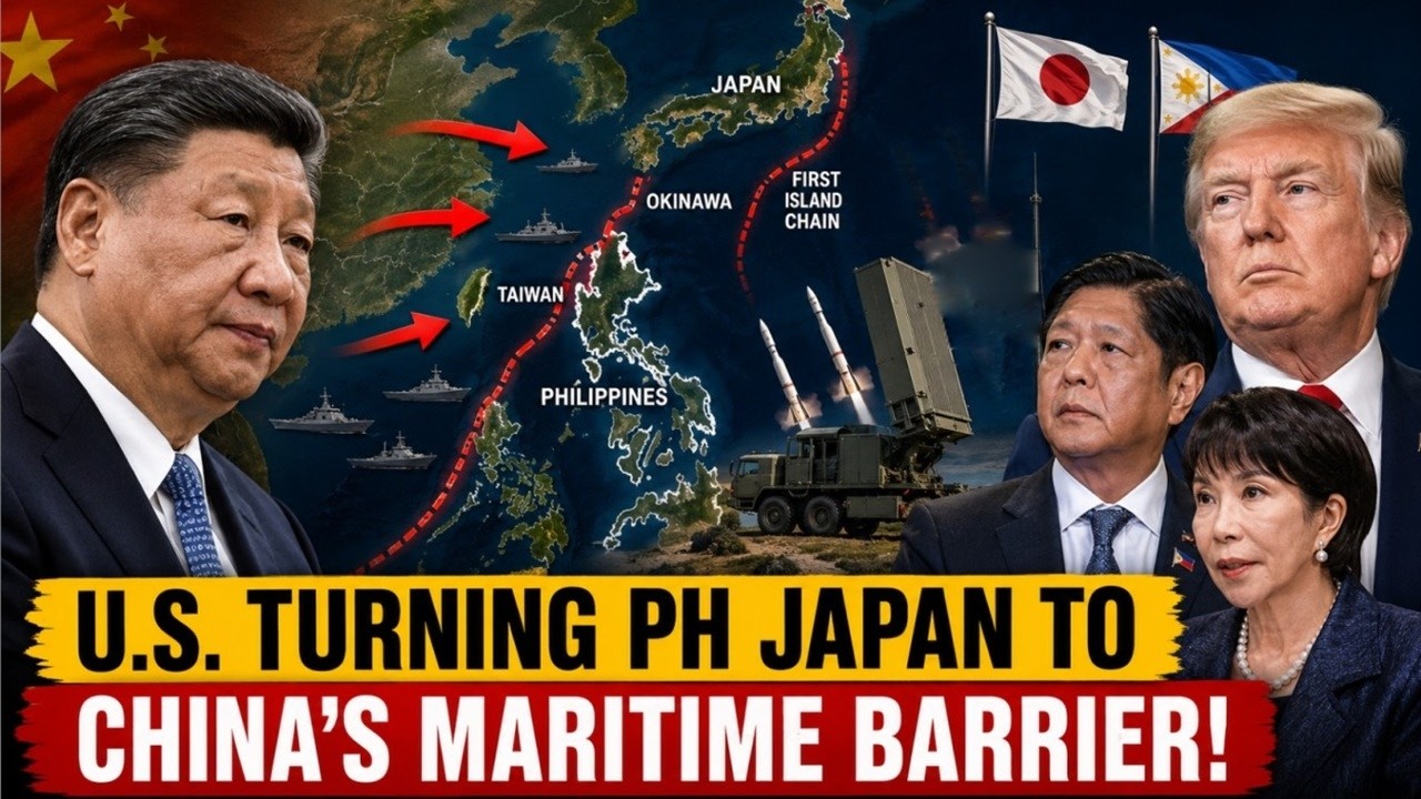
U.S. Is Turning Philippines Japan into China’s Maritime Barrier
The U.S. is deploying advanced missile systems across Japan and strengthening alliances throughout the Indo-Pacific. But the real strategic advantage isn’t just military technology—it’s geography. Here’s why the First Island Chain has become the centerpiece of America’s strategy to counter China’s growing influence.
The Most Powerful U.S. Weapon Against China Isn’t an Aircraft Carrier
For decades, the world has viewed American military power through the lens of aircraft carriers, stealth bombers, and nuclear submarines. These platforms have long symbolized Washington’s ability to project force across the globe.
However, America’s most significant strategic advantage against China may not be a single weapon system at all. Instead, it may be a chain of islands stretching from Japan through Taiwan to the Philippines—known as the First Island Chain.
The recent deployment of the U.S. Typhon missile system to southern Japan marks more than another military exercise. It signals a major shift in American strategy across the Indo-Pacific. Rather than relying solely on naval dominance, Washington is increasingly using geography, alliances, and land-based missile networks to strengthen regional deterrence.
This evolving strategy reflects a broader reality: in modern geopolitics, controlling strategic geography can be just as important as possessing advanced military technology.
Geography Still Shapes Global Power
History repeatedly shows that geography remains one of the most enduring factors in international politics. Governments rise and fall, military technology evolves, and alliances change—but geography rarely does.
In East Asia, the First Island Chain is one of the world’s most strategically important geographic features. Stretching from Japan’s main islands through Okinawa and the Ryukyu Islands, across Taiwan, and down to the northern Philippines, it forms a natural maritime barrier between mainland Asia and the Pacific Ocean.
Geography Still Shapes Global Power
One of the oldest and most enduring principles of geopolitics is that geography continues to shape the rise and fall of nations. Governments may change, military technology may evolve, and global alliances may shift over time, but geography remains constant. It influences where countries build their military bases, how they protect their borders, where global trade flows, and how major powers compete for influence. This is why many geopolitical scholars argue that geography is often more powerful than politics itself when determining a nation’s long-term strategic position.
Nowhere is this reality more evident than in the Indo-Pacific region, where the First Island Chain has become one of the most strategically important geographic features in the world. Stretching from Japan’s main islands through Okinawa and the Ryukyu Islands, across Taiwan, and down to the northern Philippines, this chain of islands forms a natural maritime barrier separating mainland Asia from the vast Pacific Ocean. Although these islands belong to different countries, together they create a strategic corridor that has enormous military, economic, and geopolitical significance.
For China, the First Island Chain presents both an opportunity and a challenge. As Beijing continues expanding the capabilities of the People’s Liberation Army Navy (PLAN), gaining unrestricted access to the Pacific Ocean has become increasingly important. However, Chinese naval forces must pass through several narrow maritime chokepoints before reaching the open Pacific. These include the Miyako Strait, located between Japan’s Ryukyu Islands; the Taiwan Strait, which separates mainland China from Taiwan; the Bashi Channel, situated between Taiwan and the Philippines; and the Luzon Strait, which connects the South China Sea to the Philippine Sea. These waterways serve as critical gateways for both commercial shipping and naval operations, making them some of the most closely monitored maritime passages in the world.
The strategic importance of these chokepoints extends far beyond China. The United States, Japan, and other regional allies regularly conduct surveillance missions, freedom of navigation operations, and joint military exercises in these waters to maintain regional stability and ensure that international sea lanes remain open. During any future crisis involving Taiwan or the South China Sea, these narrow passages would likely become key operational areas for naval fleets, submarines, and air forces. Their control could significantly influence the outcome of any regional conflict.
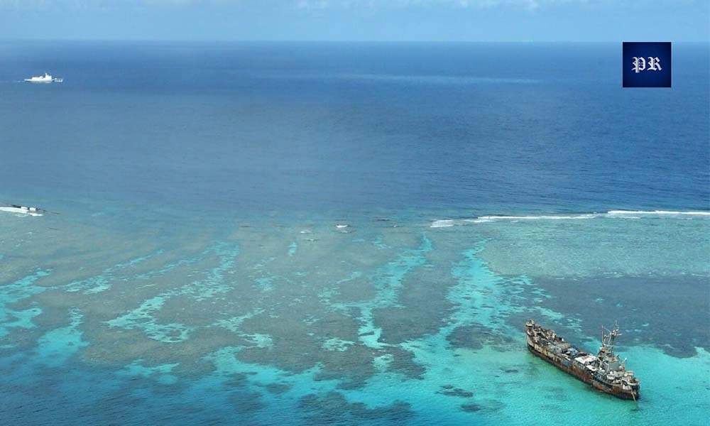
If War Breaks Out Between China and the Philippines, Who Would Support Manila?
Why China Sees the First Island Chain as Strategic Encirclement
China’s rapid economic rise has made maritime access more important than ever.
As the world’s largest trading nation, China depends heavily on sea lanes for energy imports, exports, and global commerce. Its growing navy also seeks greater freedom to operate beyond coastal waters.
Yet geography creates significant challenges. To reach the Pacific Ocean, Chinese naval forces must navigate through a handful of narrow maritime passages that can be monitored—or potentially restricted—during a conflict. From Beijing’s perspective, this creates what many Chinese strategists describe as strategic encirclement.
Rather than viewing the First Island Chain as a natural geographic feature, China increasingly sees it as a network of allied territories that constrains its military and economic ambitions. This concern has historical precedents. Before the First World War, Imperial Germany struggled against Britain’s overwhelming naval power. During the Cold War, the Soviet Union faced similar challenges in accessing the Atlantic through NATO-controlled chokepoints.
China now confronts a comparable strategic dilemma: geography appears to favor its competitors. As a result, breaking through the First Island Chain has become a long-term objective of Chinese military modernization.
America’s Strategic Shift: From Aircraft Carriers to Missile Networks
For nearly eighty years, American strategy in the Pacific relied heavily on aircraft carriers.
Carrier strike groups allowed the United States to respond quickly to crises, reassure allies, and maintain maritime dominance across the Indo-Pacific.
However, China’s military modernization has changed the strategic landscape.
Over the past two decades, Beijing has invested heavily in long-range ballistic missiles, anti-ship cruise missiles, hypersonic weapons, and sophisticated surveillance systems designed to challenge large naval formations.
These capabilities have forced U.S. military planners to rethink traditional approaches.
Instead of concentrating military power aboard a few high-value ships, Washington is increasingly investing in distributed deterrence—a network of mobile missile launchers, expeditionary forces, and dispersed military positions spread across allied territory.
One of the most important systems supporting this strategy is the Typhon missile launcher.
Capable of firing both Tomahawk cruise missiles and SM-6 missiles, Typhon provides long-range strike capabilities while remaining highly mobile and difficult to target.
Unlike aircraft carriers, which represent concentrated military power, mobile missile systems can be dispersed across numerous islands, making them more survivable in a high-intensity conflict.
This strategic transition reflects a broader evolution in modern warfare: flexibility, mobility, and geographic positioning are becoming just as important as firepower.
Japan Has Become the Center of America’s Indo-Pacific Strategy
Among all U.S. allies in Asia, Japan occupies perhaps the most important geographic position.
Its southwestern islands—including Okinawa, Miyako, Ishigaki, and Yonaguni—form the backbone of the First Island Chain and lie close to Taiwan.
Yonaguni Island, for example, is located less than 110 kilometers from Taiwan, highlighting Japan’s growing importance in regional security planning.
The United States already maintains extensive military infrastructure across Japan, including air bases, naval facilities, logistics hubs, and the headquarters of the U.S. Seventh Fleet.
Recent exercises such as Resolute Dragon 2026 and Valiant Shield 2026 demonstrate how quickly this cooperation is expanding.
American Typhon missile systems, HIMARS launchers, Marine Littoral Regiments, and joint command centers are now operating across Japan’s southwestern islands, strengthening the alliance’s ability to respond to regional contingencies.
Rather than temporary deployments, many analysts see these developments as part of a long-term strategy to enhance deterrence throughout the Indo-Pacific.
About Indo-Pacific Report
For more geopolitical analysis, strategy coverage, and Indo-Pacific security reporting, visit Indo-Pacific Report:
Website
Facebook
YouTube
U.S. Is Turning Philippines Japan into China’s Maritime Barrier