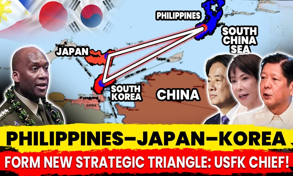
What if everything we thought we knew about Indo-Pacific strategy changes with a simple twist of a map? That’s the provocative idea behind U.S. Forces Korea’s adoption of the “east-up” map, a flipped geographic perspective that suddenly places South Korea, Japan, and the Philippines along a striking strategic axis. And according to the USFK Commander, this isn’t just a cartographic experiment; it reveals a powerful “strategic triangle” emerging at the heart of the region’s defense architecture. In an era defined by intensifying Sino-U.S. rivalry, this new way of looking at the Indo-Pacific raises an unsettling question: Is geography showing us the alliances of the future before diplomacy does?
Background: The East-Up Map Concept
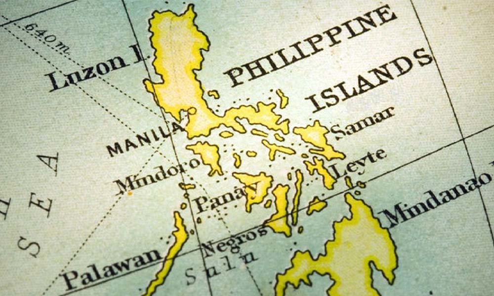
The “east-up” map is a simple yet radical reorientation of the traditional world map: instead of placing north at the top, it rotates the view so that the eastern direction sits at the peak. At first glance, it may seem like nothing more than a creative visual tweak. But this reorientation fundamentally reshapes how the Indo-Pacific’s geography and its security relationships are perceived. By flipping the map, countries typically seen on the periphery suddenly take center stage. This perspective is particularly striking because it visually elevates South Korea’s southern neighbors, especially the Philippines and Taiwan, bringing them into a clear line of sight. Instead of appearing “below” or “distant,” these partners appear directly along Korea’s forward-facing strategic plane. The result is a geographic layout that instinctively highlights their importance to collective defense and regional stability. It changes the mental map of the region from a vertical north–south interpretation to a dynamic east–west field of interconnected security nodes.
More importantly, the east-up map offers a fresh lens for analyzing alliance structures in an increasingly contested Indo-Pacific. It reveals patterns that conventional mapping hides: shared vulnerabilities, overlapping maritime spaces, and the natural alignment of U.S. allies forming a defensive arc from the Korean Peninsula to Japan and down to the Philippines. In an era of rising Chinese military activity and intensifying great-power competition, the east-up perspective forces both policymakers and military planners to reconsider how geography shapes strategy and whether traditional map orientations have been obscuring the very alliances now becoming essential.
Emergence of the Strategic Triangle
U.S. Forces Korea Commander Gen. Xavier Brunson has introduced a compelling new way to visualize Indo-Pacific security: a “strategic triangle” linking South Korea, Japan, and the Philippines. His remarks, delivered in the context of the east-up map, highlight a reality that has long been felt but rarely articulated, these three U.S. allies are not merely separate defense partners, but interconnected pillars forming a wider regional security architecture. Brunson’s framing suggests that when the map is rotated, so too must be the mindset of policymakers: the Indo-Pacific is no longer a collection of bilateral ties, but a triangulated network with shared vulnerabilities and shared responsibilities.
What makes this triangle so powerful is its conceptual shift. Instead of seeing Seoul, Tokyo, and Manila as isolated participants in their own bilateral alliances with Washington, the east-up view reveals how their positions naturally align into a cohesive strategic shape. Each point of the triangle covers a critical doorway into the region, South Korea protects the northern gateway, Japan secures the western Pacific corridor, and the Philippines anchors the southern flank of the South China Sea. Together, they form a geographic geometry that creates overlapping deterrence zones and amplifies their collective ability to respond to threats, whether from China, North Korea, or regional instability.
Importantly, Brunson is not proposing the creation of a new NATO-style alliance, something that would be politically unrealistic in Asia. Instead, the “strategic triangle” is a practical framework for strengthening existing ties, improving communication channels, and coordinating military activities across the three nations. This means more intelligence sharing, better alignment of maritime domain awareness systems, increased trilateral exercises, and a unified understanding of threats that cross borders, seas, and airspace. It is about recognizing that geography provides a natural blueprint, and that today’s security challenges demand allies stop thinking in silos and start operating as a connected whole.
Role of Individual Countries in the Triangle
Within Gen. Brunson’s “strategic triangle,” each corner plays a distinct and surprisingly complementary role, forming a defensive geometry that stretches from the Korean Peninsula down to the heart of the South China Sea. Rather than three disconnected allies reacting to crises in their own neighborhoods, the east-up perspective reveals how each nation contributes a unique capability that, when combined, produces a far more potent regional deterrent. This isn’t just cartography, it’s strategy elevated by geography.
South Korea, positioned at the apex of the triangle, emerges as the natural pivot. Its central northern location places it within direct reach of three nuclear-armed or near-peer adversaries: North Korea, China’s Northern Theater Command, and even Russia’s Pacific assets. Few countries sit at the crossroads of so many critical military vectors. South Korea’s ability to impose costs, from missile defenses to advanced naval and air capabilities, gives it an outsized role in shaping the triangle’s northern stability. Its proximity to Pyongyang, Beijing, and Vladivostok is not just a vulnerability; it is a force multiplier that can shape how all three adversaries allocate their military resources.
Japan, by contrast, anchors the eastern flank with technological sophistication and unmatched maritime reach. As a frontline state facing both North Korean missiles and China’s expanding naval presence, Japan has transformed into a powerhouse contributor to regional deterrence. Its Aegis destroyers, anti-submarine warfare capabilities, and advanced intelligence infrastructure serve as the triangle’s early-warning backbone. When viewed on the east-up map, Japan becomes less an isolated island nation and more a crucial connective node linking the northern and southern ends of the triangle, enabling rapid response and integrated defense.
The Philippines forms the southern point, the one closest to the South China Sea’s rapidly militarizing waters. Its value is not measured by sheer firepower but by geography: access to the most contested sea lanes in the Indo-Pacific. With EDCA sites, expanded maritime surveillance, and a frontline seat to Chinese coast guard and militia activities, the Philippines gives the triangle visibility and reach into the region’s most volatile flashpoint. Its position not only enhances maritime domain awareness but also enables allied mobility across chokepoints that China seeks to dominate.
These roles form a triangle whose strength lies in its diversity: South Korea’s northern deterrence power, Japan’s maritime and technological edge, and the Philippines’ southern access and situational awareness. None can cover the Indo-Pacific alone, but together, they outline a strategic shape that could redefine regional security for the next decade.
https://www.youtube.com/watch?v=o02nDWfq0L0
Strategic Implications
The “strategic triangle” is not just a clever geographic metaphor, it carries profound implications for how the Indo-Pacific’s security architecture is evolving. By linking South Korea, Japan, and the Philippines into a single conceptual framework, Gen. Brunson highlights a form of collective deterrence that is stronger than the sum of its parts. The moment these three allies are viewed as interconnected rather than isolated, their combined military and geopolitical leverage becomes unmistakable.
Each corner of the triangle brings a different capability to the table, South Korea’s firepower and northern deterrent posture, Japan’s maritime strength and technological systems, and the Philippines’ geographic access to the South China Sea. When layered together, they create a web of surveillance, military reach, and political coordination that complicates any adversary’s calculations. Whether the threat comes from North Korea launching missiles, China pushing harder in the Taiwan Strait or the South China Sea, or Russia expanding its Pacific activity, the triangle offers a multi-directional shield backed by real capabilities.
No single regional partner holds as much cross-theater influence as South Korea. Situated at the triangle’s northern vertex, it sits within immediate strategic reach of three major flashpoints: the Korean Peninsula, China’s Northern Theater Command, and Russia’s Pacific Fleet area. This makes the peninsula a commanding high ground in Indo-Pacific geopolitics, a location whose political alignment and readiness can shape the behavior of Beijing, Pyongyang, and Moscow simultaneously. The triangle amplifies this reach, turning Korea’s proximity from a risk into an advantage for the entire network.
Forces stationed in Korea are already forward-deployed, trained for rapid escalation scenarios, and accustomed to high-tempo readiness. This eliminates the long delays and logistical hurdles of bringing reinforcements from overseas. When integrated with Japan’s logistics hubs and the Philippines’ southern access points, the triangle forms a pre-positioned, geographically distributed force posture. This means crisis response, whether missile launches from the DPRK or coercive maneuvers in the South China Sea, requires less time, fewer assets, and minimal political friction.
Perhaps the triangle’s most understated advantage is its ability to adapt to emerging contingencies. With Taiwan sitting almost in the geometric center of the triangle on an east-up map, the arrangement naturally supports flexible response options to a Taiwan Strait crisis. Japan provides air and naval support, South Korea contributes surveillance and readiness capabilities, and the Philippines offers southern basing options that prevent China from controlling the battlespace. This flexibility doesn’t create a new alliance, it creates a strategic scaffold that the U.S. and its partners can rapidly leverage as tensions shift.
Context of U.S.-Regional Security
The foundation of this emerging “strategic triangle” is the enduring presence of 28,500 U.S. troops stationed in South Korea, one of the largest and most battle-ready American deployments anywhere in the world. This force, backed by ongoing modernization initiatives, advanced missile defense systems, and rapid-reaction capabilities, anchors the northern edge of the Indo-Pacific security architecture. It is not just a deterrent against North Korea; it is a forward-operating platform that reinforces U.S. commitments across the region.
This context becomes even more urgent when viewed against the accelerating Sino–U.S. rivalry, which increasingly defines the Indo-Pacific’s strategic environment. China’s military assertiveness, ranging from gray-zone pressure in the South China Sea to rapid missile modernization and naval expansion has shifted the balance of power. At the same time, the deepening alignment between North Korea and Russia introduces a new layer of complexity: Pyongyang gains diplomatic cover and military cooperation, while Moscow gains a disruptive partner in East Asia. For Washington and its allies, this creates a three-front strategic challenge that cannot be managed through isolated bilateral relationships.
That is precisely why the east-up mapping concept has gained traction within USFK. By rotating the map and placing “east” at the top, familiar geopolitical relationships are recast in a new light. The Philippines and Taiwan suddenly appear as South Korea’s “upper neighbors,” while Japan connects horizontally across a shared security plane. This visual reframing does more than change orientation, it forces policymakers to see the Indo-Pacific as an interconnected lattice of overlapping threats and shared defenses, not merely a collection of separate U.S. alliances. In effect, the east-up map symbolizes a shift from bilateralism to networked security, revealing linkages that traditional maps obscure.
The East-Up Map and the Emergence of a Korea-Japan-Philippines Strategic Triangle: A Detailed Analysis
The east-up map represents a deliberate reorientation of the conventional north-up worldview. By rotating the map so that east appears at the top, this approach challenges longstanding visual biases and forces new ways of understanding regional geography. In an east-up layout, South Korea sits prominently at the center-top, while its southern neighbors, the Philippines and Taiwan, rise into sharper focus than on traditional projections. This visual adjustment is not merely aesthetic. It emphasizes how the Korean Peninsula is geographically tied to a wider arc of strategic partners, encouraging policymakers and military planners to view the region as a coherent, interconnected space rather than a set of disparate bilateral relationships. Through this shift in perspective, the east-up map offers a fresh lens for interpreting alliance behavior, security dynamics, and operational planning across the Indo-Pacific.
Emergence of the Strategic Triangle
The idea of a strategic triangle linking South Korea, Japan, and the Philippines was articulated by General Xavier Brunson, the commander of U.S. Forces Korea (USFK). His remarks showed that these nations should not be seen as isolated partners but as vertices of a larger, mutually reinforcing structure. Instead of constructing a new formal alliance, Brunson described a framework that recognizes the geography that already connects these countries and the strategic logic that increasingly binds their defense interests. By visualizing these allies as a triangle, rather than separate partners tethered only to the United States, this conceptual shift highlights substantial collective potential. Each side of the triangle represents a different avenue of shared interest: the defense of the Korean Peninsula, the security of the East China Sea, and the stability of the South China Sea. The goal is not to create binding defense treaties but to enhance coordination, facilitate interoperability, and deepen awareness of how each nation’s position contributes to a shared regional architecture.
$35B War Machine: How the Philippines is Reshaping Its Military!
Role of Individual Countries Within the Triangle
South Korea occupies the geographically central and northernmost point of the triangle. This position makes Seoul a natural strategic pivot in Northeast Asia. Its proximity to Pyongyang, Beijing, and Vladivostok gives South Korea a unique ability to impose costs across multiple axes. From the Korean Peninsula, allied forces can deter or respond to provocations from North Korea, while simultaneously influencing the operational calculus of China’s Northern Theater Command and even Russia’s Pacific and Northern Fleets. Moreover, the density of South Korea’s capabilities—its advanced military systems, robust infrastructure, and existing U.S. troop presence—functions as a powerful force multiplier for the entire triangle. Japan anchors the northeastern flank of the triangle, bringing formidable maritime and technological capabilities. With its advanced fleet, cutting-edge sensors, and integrated intelligence systems, Japan enhances the collective capacity for maritime domain awareness, missile defense, and multi-domain deterrence. Its location near key chokepoints, combined with its alliance with the U.S., enables Tokyo to play a decisive role in stabilizing the East China Sea and supporting operations across the region, including those related to Taiwan or broader contingencies. The Philippines occupies the southern vertex of the triangle, connecting Northeast Asia to the South China Sea, one of the world’s most contested maritime spaces. Its strategic geography, situated along vital sea lanes and near potential flashpoints, offers partners access to critical southern corridors. Beyond hosting key locations under the U.S.-Philippines Enhanced Defense Cooperation Agreement (EDCA), the Philippines strengthens maritime domain awareness, logistical mobility, and the ability to project stability across Southeast Asian waters. Combined, these strengths expand the strategic depth of the triangle far beyond the Korean Peninsula.
Strategic Implications of the Triangle
When the capabilities of South Korea, Japan, and the Philippines are viewed collectively, they form a robust deterrent against regional aggression. The triangle concept reinforces the idea that deterrence is not just a function of bilateral alliances with the U.S., but of a distributed, mutually reinforcing network of partners capable of covering each other’s vulnerabilities. South Korea’s northern location provides reach into three major strategic theaters: North Korea, China, and Russia. When integrated with Japan’s maritime strength and the Philippines’ southern access points, the triangle creates the potential for coordinated pressure and flexibility across a wide range of scenarios—from North Korean provocations to tensions in the Taiwan Strait or South China Sea.
The significant U.S. presence on the Korean Peninsula—combined with South Korea’s own high state of readiness—means that forces are already forward-positioned in a strategically decisive location. This pre-positioning reduces the demand for reinforcement during crises and enables rapid contributions to contingencies outside the Peninsula, should circumstances require. The triangle concept enhances the adaptability of U.S. and allied forces. By understanding the region as an interconnected space, the U.S. and its partners gain greater ability to shift assets, share intelligence, and coordinate operations in response to evolving tensions, including potential flashpoints around Taiwan or the South China Sea.
https://indopacificreport.com/35b-war-machine-how-the-philippines-is-reshaping-its-military/
Context of Broader U.S.-Regional Security Dynamics
The foundation of this evolving structure lies in the longstanding U.S.-South Korea alliance, supported by the presence of 28,500 U.S. troops under USFK. Ongoing modernization efforts ranging from command-and-control upgrades to expanded trilateral cooperation with Japan, reflect Washington’s aim to strengthen interoperability and prepare for multi-domain challenges.
At the same time, the Indo-Pacific strategic environment is changing rapidly. China’s growing assertiveness, especially in the East and South China Seas, combined with the deepening alignment between North Korea and Russia, creates new and overlapping layers of risk. Understanding these dynamics through the east-up map helps policymakers recognize the interconnectedness of threat vectors and the geographic logic behind emerging partnerships. This perspective moves beyond the traditional bilateral mindset and situates regional security within a networked framework.
Regional Reactions
Pyongyang responded angrily to the east-up map, branding it a “map for invasion.” The DPRK’s interpretation reflects its sensitivity to any U.S. efforts that signal regional integration or enhanced allied coordination. For North Korea, the map’s reorientation appears as a symbolic blueprint for containment and military pressure, reinforcing its confrontational rhetoric and justifying its ongoing military buildup. The map serves as a powerful signaling tool. To adversaries, it shows that the U.S. is actively shaping a regional defense posture that spans from Northeast Asia to the South China Sea. To allies, it communicates that the U.S. sees them not simply as bilateral partners but as components of a larger, coherent security network. For South Korea, Japan, and the Philippines, the east-up map clarifies their interconnected roles. It visually demonstrates how each contributes complementary strengths to a broader security architecture. This shared perspective helps solidify collective commitment to Indo-Pacific stability and the protection of the rules-based international order.
Conclusion
The east-up mapping approach offers more than a cartographic novelty, it reshapes how strategists understand the Indo-Pacific by placing South Korea, Japan, and the Philippines into a clear, interconnected strategic triangle. This reorientation highlights geographic realities that conventional maps obscure, revealing how these three nations collectively form a stabilizing arc from Northeast Asia to the South China Sea.
Together, their complementary capabilities, geographic advantages, and deepening coordination create a multilayered deterrent against regional threats. South Korea’s northern leverage, Japan’s maritime and technological strength, and the Philippines’ access to critical southern sea lanes form a network that enhances operational flexibility, improves regional awareness, and strengthens the broader U.S.-led security architecture.
Looking ahead, the triangle shows the continued evolution of U.S. strategy in a region defined by intensifying geopolitical competition. As China grows more assertive and North Korea-Russia alignment deepens, alliance cohesion and integrated planning will become increasingly essential. By reframing the region through the east-up lens, the United States and its partners gain not just a new way of seeing the map but a clearer understanding of how to navigate the Indo-Pacific’s emerging strategic landscape.