INDOPACIFIC REPORT | Geo-Politics | Analysis
Published: April 1, 2026 | Updated: April 1, 2026 | By IndoPacific Report Editorial
China’s Secret Artificial Island at Antelope Reef: The Biggest Island-Building Project in the South China Sea Since 2017
Satellite imagery reveals 1,490 acres of reclaimed land, over 30 dredging ships invisible to tracking systems, and a possible 9,000-foot military runway — all constructed in five months while the world watched the Iran crisis.
• • •
China is building its largest artificial island ever at Antelope Reef in the Paracel Islands, according to satellite imagery analysed by the Asia Maritime Transparency Initiative (AMTI) at the Center for Strategic and International Studies in Washington. The construction, which began in October 2025, represents the first significant Chinese island-building operation in the South China Sea since 2017 — and it has unfolded almost entirely out of public view.
In five months, what was once described as “little more than a sandbar” has been transformed into a landmass of approximately 1,490 acres. That is nearly the size of Mischief Reef, China’s current largest outpost, which measures 1,504 acres. If construction continues at the current pace, Antelope Reef will surpass every artificial island Beijing has ever built.
Where Is Antelope Reef and Why Does It Matter?
Antelope Reef lies in the Crescent island group in the southwestern Paracel Islands. It is located approximately 162 nautical miles from China’s Sanya naval base on Hainan island and 216 nautical miles from Da Nang, Vietnam. The reef is known as Lingyang Jiao in Chinese and Da Hai Sam in Vietnamese. Both Vietnam and Taiwan also claim the feature.
China has controlled the Paracel Islands since seizing them from South Vietnam in a brief naval battle in January 1974 — a weekend engagement that changed the map of the South China Sea permanently. Beijing now maintains twenty outposts across the archipelago, including the heavily militarised Woody Island, which serves as its administrative hub for the entire South China Sea.https://www.youtube.com/watch?v=7tsv6Z8N7Iw
Until late 2025, Antelope Reef was one of the smallest and least developed of these outposts. Two buildings. Minimal infrastructure. Then, sometime after October 15, dredging vessels began to arrive.
What Satellite Imagery Shows: A Timeline of Construction
December 2025: Two large cutter-suction dredgers arrived at the reef, accompanied by roll-on/roll-off transport vessels carrying heavy equipment. The UK-based Open Source Centre was the first to document the activity.
January 2026: Twelve dredgers were operating inside the lagoon. New infrastructure appeared: a clearly defined access channel, roll-on/roll-off berths for landing construction machinery, and prefabricated shelters on newly created land. Satellite analysis by Janes Defence confirmed the transformation.
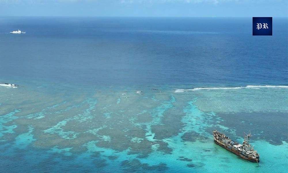
February 2026: Twenty-two dredgers were at work simultaneously. Planet Labs imagery showed familiar patterns — straight quay walls for ship berthing, a large sheltered anchorage cleared of coral, a deep entrance channel, and open space for base infrastructure. Critically, not a single vessel appeared on commercial AIS ship tracking systems.
March 2026: Over thirty vessels were spotted inside the lagoon. AMTI published its landmark analysis on March 20, estimating 1,490 acres of reclaimed land. More than fifty small grey-roofed structures had appeared, along with a helipad, jetty foundations, and what appears to be a concrete plant. A straightened edge along the northwestern side of the reef extends over 11,000 feet — suitable for a 9,000-foot military runway.https://indopacificreport.com/antelope-reef-chinas-growing-military-foothold-in-the-south-china-sea/
Could Antelope Reef Get a Military Runway?
AMTI’s analysis is direct on this point. The think tank wrote that Antelope Reef “could now accommodate a 9,000-foot runway of the type China has already constructed at Woody Island, Mischief Reef, Subi Reef, and Fiery Cross Reef.” Each of those four runways currently hosts fighter jets, bombers, and KJ-500 early warning aircraft.
Gregory Poling, director of the Southeast Asia Program and AMTI at CSIS, has previously noted that China’s artificial island network allows Beijing to “see and hear and communicate across the whole South China Sea in a way that nobody else, including the United States, can.” Antelope Reef would add another node to that network, pushing Chinese surveillance closer to Vietnam’s central coast.
For a detailed analysis of how this expanding network affects the Philippines, see our coverage of how China’s surveillance capabilities impacted Philippine Coast Guard operations at Scarborough Shoal, including the first reported Starlink signal jamming incident in February 2026.
Why China Built This Island While the World Watched Iranhttps://www.youtube.com/watch?v=QeJ6dst1sgU
The timing of the construction is significant. China began dredging at Antelope Reef in October 2025, months before the US and Israel launched strikes against Iran in February 2026. By the time the Strait of Hormuz crisis consumed global attention — and the Philippines declared its first-ever national energy emergency — Antelope Reef was already months into construction with over thirty ships operating around the clock.
Antelope Reef: China’s Growing Military Foothold in the South China Sea
This pattern is consistent with Beijing’s historical approach to island-building. In 1974, China seized the Paracels while the United States was withdrawing from Vietnam. From 2013 to 2016, China built 3,200 acres of artificial islands in the Spratly Islands while the Obama administration debated its response. In 2012, China took effective control of Scarborough Shoal while diplomatic negotiations were still ongoing.
Each time, Beijing moved during a window of distraction. Each time, the international community protested after the concrete had dried. For our analysis of how this pattern connects to the Philippines’ current energy crisis, read Is Marcos Selling the West Philippine Sea to China for Oil?
Vietnam Protests — But Five Months Late
Vietnam issued a formal protest on March 22, 2026. Foreign Ministry Spokeswoman Pham Thu Hang stated: “Any foreign activities conducted in Hoang Sa, including Hai Sam reef, without Vietnam’s permission are completely illegal and invalid. Vietnam resolutely opposes such activities.”
China’s response came two days later. Foreign Ministry Spokesperson Lin Jian said: “Xisha Qundao is China’s inherent territory, over which there is no dispute. Necessary construction on our own territory is aimed at improving living and working conditions on the islands.”
That language — “limproving living and working conditions” — is identical to what Beijing said about Mischief Reef in 1995, before it became a military base with a 10,000-foot runway, fighter jet hangars, anti-ship cruise missiles, and surface-to-air missile systems.
How Antelope Reef Affects the Philippineshttps://indopacificreport.com/antelope-reef-a-strategic-shift-in-the-south-china-sea/
Although Antelope Reef sits in the Paracel Islands rather than the Spratlys where Philippine territorial disputes are concentrated, the strategic implications for Manila are direct. Every Chinese base in the South China Sea feeds into an integrated surveillance and electronic warfare network that pressures Philippine operations.
In February 2026, the Philippine Coast Guard reported that China was jamming Starlink satellite connections on government vessels whenever they approached within 24 nautical miles of Scarborough Shoal. Those electronic warfare capabilities are enabled by the network of bases that Antelope Reef is about to strengthen.
Poling has written that destroying China’s major Spratly outposts alone could require up to 300 missiles, with 100 more for Woody Island and dozens more for smaller outposts. A CSIS report by Seth Jones found that the US would likely run out of long-range precision munitions in less than a week during a Taiwan contingency. Every new island China builds raises the military cost of challenging the entire network.
For a comprehensive analysis of how these capability gaps affect Manila, see our report: China Is Watching the Philippines Fight Two Wars at Once. And for coverage of the US response, read $2.5 Billion: America’s Biggest Bet on the Philippines Since the Cold War.
What Happens Next
If previous Chinese island-building projects are any guide, the next phases at Antelope Reef will follow a predictable sequence: runway construction within six to eighteen months, followed by radar installation, communications arrays, hardened storage facilities, and eventually the deployment of fighter aircraft, electronic warfare systems, and missile batteries.
Mischief Reef took twenty years from first occupation to full militarisation. But the pace is accelerating. Antelope Reef has been reclaimed faster than any previous Chinese island-building project. The question is no longer whether China will finish this island. It will. The question is what the Philippines, Vietnam, Japan, Australia, and the United States are prepared to do before the next reef starts.https://www.youtube.com/watch?v=QeJ6dst1sgU
• • •
Frequently Asked Questions
Q: Where is Antelope Reef?
Antelope Reef is located in the Crescent island group in the southwestern Paracel Islands in the South China Sea. It sits approximately 162 nautical miles from China’s Sanya naval base on Hainan and 216 nautical miles from Da Nang, Vietnam. The feature is claimed by China, Vietnam, and Taiwan.
Q: How big is the artificial island at Antelope Reef?
As of March 2026, the Asia Maritime Transparency Initiative estimates that approximately 1,490 acres (6.02 square kilometres) of land has been reclaimed at Antelope Reef. This is nearly equal to Mischief Reef (1,504 acres), currently China’s largest artificial island in the South China Sea.

Q: Is China building a military runway at Antelope Reef?
AMTI has noted that a straightened edge along the northwestern side of Antelope Reef extends over 11,000 feet and is suitable for a 9,000-foot runway. China has built runways of this size at four other South China Sea outposts: Woody Island, Mischief Reef, Subi Reef, and Fiery Cross Reef. All four now host military aircraft.
Q: Why did China build Antelope Reef now?https://www.youtube.com/watch?v=Ce7cNAxUvaw
Construction began in October 2025, months before the Iran war and the Strait of Hormuz crisis consumed global attention. This is consistent with China’s historical pattern of advancing island-building during periods of international distraction. Vietnam’s formal protest did not come until March 2026, five months after dredging began.
Q: How does Antelope Reef affect the Philippines?
Although Antelope Reef is in the Paracels, not the Spratlys, it strengthens China’s integrated surveillance and electronic warfare network across the entire South China Sea. This network directly affects Philippine operations at Scarborough Shoal, Second Thomas Shoal, and other contested features in the West Philippine Sea.
• • •
Related Coverage from IndoPacific Report:
• Is Marcos Selling the West Philippine Sea to China for Oil?
• China Is Watching the Philippines Fight Two Wars at Once
• $2.5 Billion: America’s Biggest Bet on the Philippines Since the Cold War
• Japan’s First Military Deployment to Balikatan Terrifies China
• Can the Philippines Hold the First Island Chain?
• China Escalates Pressure on Philippine Fishermen at Scarborough Shoal
🎬 Watch the full video investigation: China’s Secret New Island: Antelope Reef Exposed — A 15-minute deep dive with satellite imagery comparisons, historical parallels, and strategic analysis. Subscribe to IndoPacific Report on YouTube for weekly coverage of South China Sea developments and Philippine defense.https://www.youtube.com/watch?v=w_LYPrJV3UQ
Sources
AMTI/CSIS, “Antelope Reef Could Now Be the Largest Island in the South China Sea,” March 20, 2026.
Open Source Centre (UK), Antelope Reef reclamation analysis, February 2026.
Janes Defence, “China begins constructing new island in South China Sea,” January 15, 2026.
The Maritime Executive, “China is Dredging Out Another Island Outpost,” February 15, 2026.
Newsweek, “Satellite Photos Show China’s Massive Manmade Island,” March 2026.
Radio Free Asia, “Vietnam protests China’s development of disputed reef,” March 23, 2026.
Chinese Foreign Ministry (Lin Jian), press conference, March 24, 2026.
Asia Times, “China’s Antelope Reef dredge deepens South China Sea tensions,” January 13, 2026.
Gregory Poling, War on the Rocks; cited in Asia Times (missile cost estimates).
Seth Jones, “Empty Bins in a Wartime Environment,” CSIS, January 2023.
Planet Labs, Vantor, and ESA Sentinel-2 satellite imagery.
Newsweek, “Chinese Military Accused of Jamming Starlink,” February 24, 2026.
• • •
About IndoPacific Report
IndoPacific Report is an independent strategic intelligence platform delivering original analysis on defense, diplomacy, and great-power competition across the Indo-Pacific. Our coverage spans the South China Sea, Philippine defense modernization, ASEAN security dynamics, and the US-China rivalry shaping the 21st century.https://youtu.be/w_LYPrJV3UQ?si=frkXF_-ikOv0xsjZ
Follow us: YouTube | Facebook | Website
© 2026 IndoPacific Report. All rights reserved.
Reproduction permitted with attribution and link to indopacificreport.com