End of “Nine Dash Line” | Vietnam and Philippines Are Redrawing the South China Sea Map
The South China Sea is no longer only a dispute over reefs and islands. It has become a contest over international law, maritime boundaries, and the future balance of power in the Indo-Pacific. Recent cooperation between the Philippines, Vietnam, Japan, and other regional actors is gradually replacing strategic ambiguity with internationally recognized maritime boundaries. This article explains why these developments matter, how they affect China’s long-standing claims, and what they mean for regional stability
THE NEW BATTLE FOR THE SOUTH CHINA SEA MAP
This month, the Philippines and Vietnam moved closer to defining their maritime boundaries under international law. At first glance, this sounds like a technical legal discussion. In reality, it may represent one of the most serious challenges to China’s South China Sea strategy in decades. Because every time two countries agree on a legal maritime boundary, the space available for China’s expansive historical claims becomes smaller. Why did China react so strongly when the Philippines and Vietnam discussed maritime boundaries?
Why did Beijing condemn Japan and the Philippines for negotiating a maritime border east of Taiwan?
And why are Chinese coast guard ships suddenly appearing in areas far beyond the traditional South China Sea disputes?
The answer has very little to do with ships.It has everything to do with maps.
Because for the first time in decades, a growing coalition of Asian states is attempting to replace China’s strategic ambiguity with internationally recognized maritime boundaries.
WHAT UNCLOS ACTUALLY DID TO THE SOUTH CHINA SEA
The immediate trigger for this emerging geopolitical contest came in June 2026.
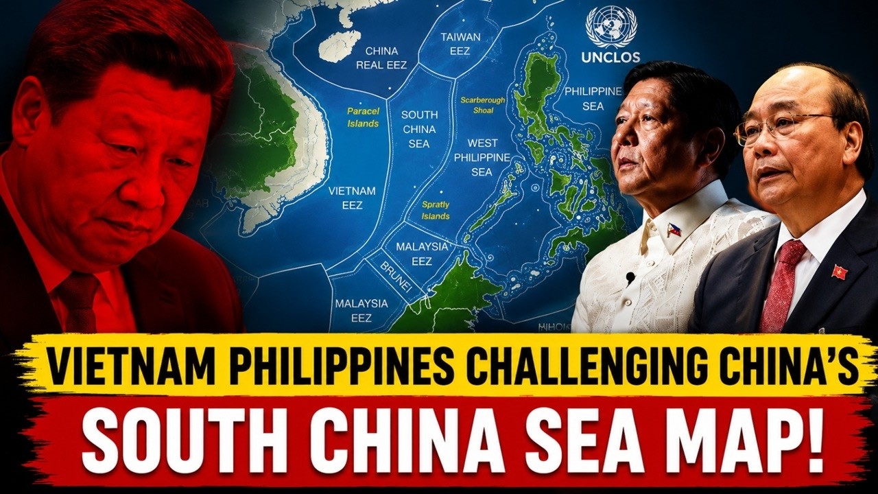
On June 1st, the Philippines and Vietnam upgraded their relationship to an Enhanced Strategic Partnership, declaring that peace, stability, freedom of navigation, and a rules-based order in the South China Sea were, in President Ferdinand Marcos Jr.’s words, “non-negotiable.” Both governments also reaffirmed their commitment to resolving maritime disputes through international law, specifically the United Nations Convention on the Law of the Sea, or UNCLOS, and the 2016 South China Sea arbitration ruling.
But this was not simply another diplomatic summit.
The Philippines and Vietnam also agreed to deepen maritime security cooperation, expand defense coordination, and strengthen coast guard cooperation in the South China Sea. These were significant steps between two countries that themselves have overlapping maritime claims in the Spratly Islands.
Then came a second development.
Japan and the Philippines announced that they would formally begin negotiations to delimit their Exclusive Economic Zones and continental shelves east of Taiwan in accordance with international law. China’s response was immediate.
Beijing declared the negotiations “completely illegal, null and void,” arguing that the maritime areas involved fell within waters associated with China’s sovereignty claims over Taiwan. Within days, the Chinese Coast Guard announced that it had begun conducting “law enforcement” patrols east of Taiwan in direct response to the Japan–Philippines negotiations.
At first glance, these events appear unrelated. A diplomatic summit in Manila.
44 Chinese Ships Are Sitting in Philippines Waters. Is This China’s New Strategy?
A maritime negotiation east of Taiwan. Chinese coast guard patrols in the Pacific. But Beijing’s reaction revealed something much larger. China was not simply objecting to a particular maritime negotiation. It was reacting to a process. A process in which regional states are increasingly attempting to replace disputed maritime space with internationally recognized legal boundaries. And nowhere is that challenge more consequential than in the South China Sea itself
WHO ACTUALLY OWNS THE SOUTH CHINA SEA?
To understand why maritime delimitation matters so much, we first need to understand a simple but revolutionary idea introduced by the United Nations Convention on the Law of the Sea.
Under modern international law, countries do not simply claim oceans because they historically sailed through them, discovered islands centuries ago, or drew lines on maps.
Instead, maritime rights are generated primarily by geography.
Under UNCLOS, coastal states may claim:
a 12 nautical mile territorial sea, where they exercise sovereignty;
a 24 nautical mile contiguous zone, where they may enforce certain laws;
and most importantly, a 200 nautical mile Exclusive Economic Zone, or EEZ, where they possess sovereign rights over fisheries, energy resources, and the seabed.
This system transformed the oceans from spaces defined largely by history into spaces defined largely by geography.
And nowhere has this transformation created more controversy than in the South China Sea.
Because seven different political entities claim rights in these waters.
And each of them believes international law supports its position.
CHINA
China’s position is unique because it combines two very different arguments.
First, like every coastal state under UNCLOS, China possesses legitimate maritime rights generated by its mainland coastline, Hainan Island, and other territories under its control.
But Beijing also advances a second argument: that China possesses historical rights within the so called Nine Dash Line.
This line, first published by the Republic of China government in 1947 and later adopted by the People’s Republic of China, encloses approximately 80 to 90 percent of the South China Sea.
Within this area, Beijing claims historical rights based on centuries of navigation, fishing activity, administration, and discovery.
China further claims sovereignty over two major island groups:
the Paracel Islands, and the Spratly Islands. If accepted, these claims would give China strategic influence over one of the world’s most important maritime regions.
However, in 2016, the Permanent Court of Arbitration ruled that China’s historical rights claims inside the Nine Dash Line had no legal basis under UNCLOS.
China rejected the ruling and continues to maintain that historical rights, historical usage, and historical administration remain valid foundations of sovereignty.
And this disagreement lies at the center of the South China Sea dispute itself.

VIETNAM
Vietnam possesses one of the longest coastlines facing the South China Sea, stretching more than 3,200 kilometers.
Like China, Vietnam claims sovereignty over both the Paracel Islands and the Spratly Islands.
However, unlike China, Vietnam’s modern maritime claims are largely framed within the legal architecture of UNCLOS.
Vietnam argues that much of the South China Sea falls within maritime zones generated by its extensive coastline.
At the same time, Hanoi also invokes historical evidence, arguing that Vietnamese dynasties exercised authority over disputed islands centuries before the emergence of modern international law. Vietnam currently occupies the largest number of features in the Spratly Islands after China.
Its strategic position is therefore unusual: Vietnam simultaneously relies upon: history, geography, and international law.
This makes Vietnam both one of China’s strongest competitors in the South China Sea and one of the strongest advocates of a rules-based maritime order.
THE PHILIPPINES
The Philippines bases almost all of its South China Sea claims on modern international law.
As an archipelagic state under UNCLOS, the Philippines generates maritime rights from its archipelagic baselines and its 200-nautical-mile Exclusive Economic Zone.
Manila refers to portions of these waters as the West Philippine Sea.
The Philippines does not claim ownership of the entire South China Sea.
Instead, it argues that several disputed features and maritime zones lie well within its internationally recognized EEZ.
This legal strategy culminated in the landmark 2016 arbitration case against China.
The tribunal ruled overwhelmingly in Manila’s favor, concluding that China’s claims to historical rights inside the Nine-Dash Line had no lawful basis under UNCLOS.
Yet the ruling also revealed one of the central paradoxes of international politics: international law can determine legal rights, but it cannot automatically enforce them. And ten years later, that contradiction remains unresolved.
MALAYSIA
Malaysia’s claims are among the most legally conservative in the South China Sea.
Unlike China and Vietnam, Kuala Lumpur generally avoids historical arguments.
Instead, Malaysia bases its claims almost entirely on:
continental shelf provisions, Exclusive Economic Zones, and maritime rights established under UNCLOS. Malaysia occupies several features in the southern Spratly Islands and has increasingly expanded its claims through submissions to the United Nations Commission on the Limits of the Continental Shelf. This legal strategy seeks to transform contested maritime areas into internationally recognized jurisdictions. And in many ways, Malaysia represents precisely the type of legal approach that concerns Beijing most.
BRUNEI
Brunei possesses the smallest and perhaps the most straightforward claim in the South China Sea.
Unlike nearly every other claimant, Brunei does not claim sovereignty over distant island groups based on history.
Instead, its claims derive almost entirely from its Exclusive Economic Zone under UNCLOS.
Brunei’s strategy reflects the purest expression of the modern maritime legal order:
if geography generates rights, then geography alone should determine those rights.
INDONESIA
Indonesia presents one of the South China Sea’s most interesting cases.
Officially, Indonesia is not a claimant to the Spratly Islands.
However, China’s Nine Dash Line overlaps with Indonesia’s Exclusive Economic Zone north of the Natuna Islands.
Jakarta rejects China’s historical rights claims entirely.
Instead, Indonesia insists that the dispute is not about sovereignty over islands.
It is about whether historical rights can override internationally recognized maritime boundaries.
This disagreement has repeatedly produced confrontations between Chinese fishing fleets, Chinese coast guard vessels, and Indonesian maritime forces.
TAIWAN
Taiwan occupies perhaps the most unusual legal position in the South China Sea.
The Republic of China government originally drew the maritime boundary that later evolved into China’s Nine-Dash Line.
As a result, Taiwan’s constitutional claims remain nearly identical to those of the People’s Republic of China.
Taiwan controls Taiping Island, also known as Itu Aba, the largest naturally occurring feature in the Spratly Islands.
Yet Taiwan simultaneously rejects Beijing’s sovereignty claims over Taiwan itself.
This creates one of the great geopolitical paradoxes of the South China Sea:
two governments that deny each other’s legitimacy continue to defend nearly identical historical maritime claims.
THE COUNTER-MAP STRATEGY
For decades, China’s strategy in the South China Sea has benefited from one crucial advantage:
ambiguity.
The Nine Dash Line never precisely defined where China’s maritime rights began or ended. It created a strategic space where overlapping claims, uncertain boundaries, and competing interpretations could coexist.
This ambiguity gave Beijing flexibility.
But today, a growing number of regional states are pursuing a very different strategy:
precision.
The Philippines and Vietnam are expanding maritime cooperation while exploring the delimitation of overlapping maritime claims under international law. At the same time, Japan and the Philippines have launched formal negotiations to delimit their Exclusive Economic Zones and continental shelves east of Taiwan in accordance with UNCLOS. China reacted by dispatching coast guard vessels into the area and declaring the negotiations “illegal.”
This trend extends beyond bilateral negotiations.
Malaysia, Vietnam, and the Philippines have increasingly used submissions to the United Nations Commission on the Limits of the Continental Shelf to formalize maritime claims through internationally recognized legal procedures. Coast guard cooperation has expanded among Southeast Asian states. Strategic partnerships have deepened. Maritime surveillance networks have grown more integrated.
Taken individually, these developments may appear technical.
Taken together, they represent something far more significant.
A growing coalition of regional states is attempting to convert disputed political space into legal geography.
In other words, they are not merely challenging China’s claims.
They are attempting to redraw the strategic map of the South China Sea itself
And this helps explain why Beijing reacted so strongly.
Because if ambiguity has historically strengthened China’s position, then legally recognized maritime boundaries could gradually do the opposite.

WHY CHINA IS WORRIED
To understand why China reacted so strongly to maritime delimitation talks, we need to understand what maritime boundaries actually do.
Every successful maritime delimitation creates three things:
internationally recognized coordinates,
internationally recognized jurisdiction,
and internationally recognized rights.
Once maritime boundaries are formally negotiated, mapped, and deposited under international legal procedures, they become far more difficult to challenge politically. They transform contested maritime space into recognized legal geography.
This is why the Philippines pursued arbitration against China in 2013.
It is why Vietnam and the Philippines are expanding maritime coordination today.
It is why Malaysia has submitted extended continental shelf claims to the United Nations.
And it is why Japan and the Philippines are negotiating maritime boundaries east of Taiwan.
From Beijing’s perspective, these are not isolated legal actions.
They are part of a broader process that could gradually replace political ambiguity with internationally recognized maritime boundaries.
The 2016 South China Sea arbitration illustrates this dilemma.
The tribunal concluded that China’s historical rights claims within the Nine-Dash Line had no legal basis under UNCLOS and that maritime rights must derive primarily from the Convention’s legal framework rather than historical usage. China rejected the ruling and argued that questions of sovereignty and historical rights could not be resolved through the arbitration process.
This reveals the deeper strategic contest unfolding in the South China Sea.
The dispute is no longer simply about reefs, islands, or fishing grounds.
It is about which map of Asia will ultimately prevail:
a map based on historical rights and strategic influence,
or a map based on coordinates, treaties, and international law.
And this raises a larger geopolitical question.
If countries such as the Philippines, Vietnam, Japan, and Malaysia continue transforming disputed maritime space into legal geography, what happens to a strategy that depends on ambiguity?
THE RETURN OF MIDDLE POWER GEOPOLITICS
For much of the past three decades, China approached the South China Sea largely as a series of bilateral disputes.
China versus the Philippines. China versus Vietnam. China versus Malaysia. China versus individual claimants. But that strategic environment is beginning to change.
Today, the South China Sea increasingly resembles a contest between China and an emerging network of middle powers.
The Philippines and Vietnam are strengthening maritime and defense cooperation.
Japan has become a major security partner for the Philippines and is expanding maritime cooperation throughout Southeast Asia.
Australia has increased its security engagement with regional states and regularly supports freedom of navigation and international maritime law.
Indonesia continues to reject China’s historical claims near the Natuna Islands, while Malaysia has increasingly relied on international legal mechanisms to defend its maritime rights.
These countries do not constitute a formal alliance.
As the influence of one major power expands, neighboring states often respond not by acting alone, but by gradually forming networks of cooperation and collective deterrence.
THE FUTURE: TWO MAPS OF ASIA
The developments we have discussed reveal a much larger transformation taking place across the Indo-Pacific.
For decades, the South China Sea was often viewed as a collection of territorial disputes: reefs, islands, fishing grounds, and competing maritime claims.
But increasingly, the dispute is becoming something much bigger.
A contest between two different ways of organizing maritime Asia.
And that raises perhaps the most important geopolitical question facing the Indo-Pacific today:
Can two competing legal maps coexist in the same ocean?
Or will the South China Sea become the first major theater where international law and great-power politics collide directly?
Because ultimately, the struggle unfolding in the South China Sea is not simply about who owns a reef.
It is about who gets to draw the map of Asia in the twenty-first century.
Conclusion
The South China Sea dispute is increasingly about competing legal and strategic visions for Asia. Whether future negotiations reduce tensions or deepen rivalry will depend on diplomacy, international law, and regional cooperation.
About Indo-Pacific Report
For more geopolitical analysis, strategy coverage, and Indo-Pacific security reporting, visit Indo-Pacific Report:
Website
Facebook
YouTube
Vietnam and Philippines Are Redrawing the South China Sea Map