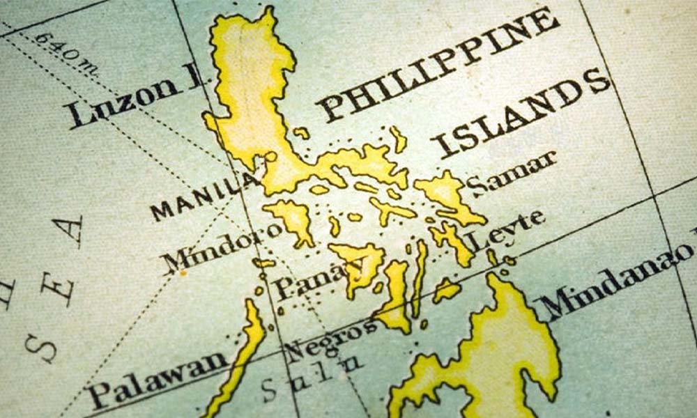
The Spratly Islands, a disputed archipelago in the South China Sea, stretch off the coasts of Malaysia, southern Vietnam, and the Philippines. This archipelago comprises of islands, islets, cays, and over 100 reefs, sometimes forming sunken ancient atolls. Despite covering an area of over 425,000 square kilo meters, the islands have less than 2 square kilo meters (490 acres) of naturally occurring land. They were named after British whaling captain Richard Spratly, who sighted Spratly Island in 1843.
Strategically located along vital shipping routes, the Spratly Islands present significant geopolitical and economic opportunities as well as challenges in Southeast Asia. Although largely uninhabited, they are crucial for establishing international borders due to their rich fishing grounds and potential reserves of natural gas and oil. While civilian settlements exist on a few islands, approximately 45 islands, cays, reefs, and shoals host military installations from Malaysia, China (PRC), Taiwan (ROC), the Philippines, and Vietnam. Additionally, Brunei claims an exclusive economic zone encompassing the uninhabited Louisa Reef in the southeastern Spratly Islands.
In 1939, the Spratly Islands were coral islets mainly inhabited by seabirds. Though naturally consisting of 19 islands, a 1986 Chinese source notes 14 islands or islets, 6 banks, 113 submerged reefs, 35 underwater banks, and 21 underwater shoals. The northeastern area, known as “Dangerous Ground,” is perilous for navigation due to its numerous low islands, sunken reefs, and degraded, submerged atolls with coral that often rises abruptly from depths exceeding 1,000 meters (3,000 feet). Each island is a cay, or sand island, formed on an ancient, eroded, and buried coral reef. The Spratly Islands, composed of biogenic carbonate lack significant agricultural land, and few possess reliable sources of drinkable water. However, their resources include huge reserves of natural gas, oil, seafood, and guano. Economic activities in the region have historically included commercial fishing, shipping, guano mining, and oil and gas extraction, with tourism emerging more recently. Global shipping lanes near the Spratly Islands further enhances their strategic importance.
Let us dive deep for a deep analysis of, “Who Owns the Spratly Islands?”
Ownership Claims
The Spratly Islands, comprising over 100 small islands and reefs, are surrounded by rich fishing grounds and potentially significant gas and oil reserves. Various countries claim parts of the islands: Malaysia and the Philippines have partial claims, while China, Taiwan, and Vietnam claim the entire archipelago. Approximately 45 islands are occupied by relatively small military units from China, Malaysia, the Philippines, Taiwan, and Vietnam. Although Brunei has not officially claimed the southern reef, it has asserted a portion of its continental shelf, overlapping with the reef since 1985, and claims an exclusive economic zone in the area.
The territorial dispute over the Spratly Islands involves Brunei, China, Malaysia, the Philippines, Taiwan, and Vietnam, with each nation seeking to advance its territorial claims. This conflict is marked by diplomatic deadlock and military pressure, including the occupation of disputed territories.
The majority of the “maritime features” in the Spratly Islands have multiple names: an international name typically in English, Chinese names that may vary between the PRC and ROC, names used by the Philippines, Vietnam, and Malaysia, and occasionally names with European origins (such as French, Portuguese, Spanish, or British). For example, Spratly Island is also known as Storm Island.
The strategic location of the region allows nations to project military power and monitor maritime activity. The Philippines claims part of the region under the United Nations Convention on the Law of the Sea (UNCLOS), a convention partially ratified by the nations involved in the dispute. However, only China (PRC), Taiwan (ROC), and Vietnam have asserted historical sovereignty over the islands.
PRC & ROC Claims
The People’s Republic of China (PRC) bases its claims to the Spratly Islands on historical evidence rather than the United Nations Convention on the Law of the Sea (UNCLOS). Despite signing the UNCLOS on July 29, 1994, the PRC maintains that it owns the entirety of the Spratly Islands. Similarly, the Republic of China (ROC), which governed Mainland China until 1949 and has since been limited to Taiwan, claims all the Spratly Islands.
China asserts that the islands were discovered during the Han dynasty in 2 BC, and supposedly marked on maps from the Eastern Han and Eastern Wu periods. However, there are no surviving maps from these eras, leaving the current Chinese government to substantiate these claims. The Yuanshi, an official history commissioned by the Ming dynasty in 1369, suggests that several islands, possibly the Spratlys, were considered Chinese territory since the Yuan dynasty in the 12th century. Maps from the Qing dynasty (1755-1912) also reportedly marked these islands as Chinese territory. Archaeological findings of Chinese coins and pottery in the islands are used as evidence by the PRC, although these artifacts likely came from passing Chinese junks.
In the 19th century, Europeans noted that Chinese fishermen from Hainan spent part of the year in the Spratlys. The British made the first formal legal claims in 1877. China protested German surveying efforts in 1883, and dispatched naval missions to the islands in 1902 and 1907, marking them with flags and monuments. The Republic of China, which succeeded the Qing dynasty, continued to assert sovereignty over the Spratlys and Paracels. Japan took control of the islands from France in 1939, but after World War II, the Allied forces designated the Republic of China to accept Japanese surrenders in these islands.
The Republic of China garrisoned Itu Aba (Taiping) Island in 1946, raising Chinese flags and establishing markers, despite French objections. The ROC’s 1947 map depicted its U-shaped claim over the entire South China Sea, including the Spratlys and Paracels. Taiwan maintained a garrison on Itu Aba from 1946 to 1950 and resumed it in 1956, considered an “effective occupation” of the islands. Despite the PRC providing geographic baselines to the UN in 1996, excluding the Spratlys, Taiwan resisted Philippine attempts to establish a presence in the islands before 1971.
In 2024, China continued to assert its claims over the Spratly Islands, citing historical sovereignty based on ancient maps and records. The Chinese government argues that these documents demonstrate a long-standing presence and control, justifying their contemporary claims. This forms part of China’s broader strategy to establish dominance in the South China Sea, despite overlapping claims from the Philippines, Vietnam, Malaysia, Brunei, and Taiwan. China’s expansive claim is encapsulated by the “New Ten Dash Line,” covering approximately 90% of the South China Sea. Despite a 2016 ruling by the Permanent Court of Arbitration in The Hague, which found no legal basis for China’s extensive claims, Beijing rejected the decision and continued to build and militarize artificial islands in the Spratlys. This includes constructing runways, missile systems, and other military infrastructure, significantly increasing regional tensions.
Diplomatically, China has engaged in prolonged negotiations with the Association of Southeast Asian Nations (ASEAN) to establish a Code of Conduct for the South China Sea, though progress remains slow and contentious.
Philippines Claim
In 2024, the Philippines continues to assert its claims over portions of the Spratly Islands, emphasizing both historical presence and proximity to its territory. The Philippines bases its claims on historical evidence of Filipino fishermen using these islands for centuries and their location within the Philippine Exclusive Economic Zone (EEZ) as defined by the United Nations Convention on the Law of the Sea (UNCLOS). Key features claimed by the Philippines include Pag-asa (Thitu) Island, the largest island in the Spratlys, as well as Second Thomas Shoal and Mischief Reef.
The Philippines maintains a small military presence on some of these islands and has pursued various legal and diplomatic avenues to support its claims. Notably, the Philippines won a landmark case in 2016 when the Permanent Court of Arbitration ruled in favor of the Philippines against China’s expansive claims. Despite this legal victory, the Philippines faces challenges in enforcing the ruling and managing tensions in the region. The country also seeks to strengthen regional cooperation through the Association of Southeast Asian Nations (ASEAN) and engages in bilateral discussions with China and other claimant countries.
Likewise, the “Moro” people refer to as the Filipino Muslims and their region in the southern Philippines. According to information from the Sultan of Sulu, the ancestors of the Moro people owned the Spratly Islands before Spanish colonists arrived in the sixteenth century. They claim that the Spratly Islands, are part of the ancestral property of the Moro people and thus outside Chinese jurisdiction and the Spratly Archipelago is part of the Sulu Sea, within the area known as the West Philippine Sea, which the Philippines claims as part of its EEZ.
Vietnam’s Claim
Vietnam’s historical connection to the Spratly Islands, known as Truong Sa, dates back centuries, with records of Vietnamese occupation, resource exploitation, and governmental control extending to the 1600s, although their involvement likely began much earlier. Vietnam’s claim is based on the principle of terra nullius (“land belonging to no state”), asserting that it has owned and occupied the territory since at least the 17th century. According to international law, “The state of Vietnam took effective possession of the Hoang Sa and Truong Sa archipelagoes long ago when they were not under the sovereignty of any nation.”
Vietnam emphasizes its historical exercise of authority and control over the islands. The first known instance of formal sovereignty was in the 1600s when the archipelago was placed under the administrative jurisdiction of the Binh Son district. For the next two centuries, pre-colonial Vietnamese governments maintained uncontested state sovereignty over the archipelago. Even after France assumed control of Vietnam through the 1887 Treaty, European powers upheld and strengthened Vietnamese authority over Truong Sa on behalf of the Vietnamese state. The French acquisition of the islands further validates Vietnam’s administrative sovereignty claims in the modern era.
After World War II, when Japan relinquished its claims to the islands, the Republic of Vietnam (RVN) continued to assert sovereignty over Truong Sa. This included protesting foreign claims, occupying the archipelago, and re-annexing the chain in 1956. The Socialist Republic of Vietnam, as the successor to the RVN, has consistently upheld Vietnamese sovereignty, even engaging in armed combat to protect its control over the islands. The Vietnamese government declared: “The state of Vietnam has always actively defended its rights and titles against all schemes and acts of encroachment upon sovereignty, territorial integrity, and interests of Vietnam in connection with the Hoang Sa and Truong Sa archipelagos.”
In the contemporary era, Vietnam occupies up to 24 features in the Spratly Islands, more than twice as many as any other claimant. At least five of these features are garrisoned by around 1,000 soldiers or sailors and construction workers. This de facto control bolsters Vietnam’s historical claims. The Law of the Sea Convention of 1982 further supports Vietnam’s rights to the Truong Sa.
Vietnam argues that the Truong Sa Islands do not generate their own continental shelves or exclusive economic zones (EEZs). Claimant states, according to Vietnam, should be entitled to a full 200-nautical-mile EEZ generated from their main coastal or large-island land areas, with high seas areas beyond 200 nautical miles governed by the International Seabed Authority. Vietnamese sovereignty claims extend to the entire archipelago, asserting a 12-nautical-mile territorial water zone for each island. Additionally, Vietnam claims a 350-nautical-mile continental shelf extending from its southeast coast towards Truong Sa. This claim is supported by seafloor geography, unlike similar claims by Malaysia, Brunei, or the Philippines.
Vietnam’s maritime heritage is deep-rooted, with historical accounts suggesting a strong seafaring tradition. While it is debatable whether the Vietnamese were the first to discover, manage, or use the islands, there is no denying their long history with Truong Sa. Vietnam’s historical claims, based on first occupation and ancient sovereignty, are validated by continuous dominance over most of the archipelago for over 300 years. This ongoing sovereignty serves as the foundation for Hanoi’s legal claims.
Vietnam has demonstrated its political will to maintain control over the islands through diplomatic and military means. This is partly in response to perceived Chinese encroachment into Southeast Asia. Vietnam’s history of resisting foreign occupation, including conflicts with China in 1979, the proxy war in Cambodia, and the 1988 fighting in Truong Sa, signifies this determination. The Vietnamese military’s persistent presence in Truong Sa is evidence of Hanoi’s resolve not to relinquish what it considers historic territory, even while expressing willingness to take the case to the International Court of Justice and engage in multilateral negotiations. Thus, Vietnam’s resolve to assert its claims and influence over the Spratly Islands remains steadfast, similar to the relentless tides washing over the archipelago.
Malaysia Claim
Six additional countries—Brunei, Indonesia, the Philippines, Singapore, Thailand, and Vietnam—have maritime borders with Malaysia. Compared to the rest of Malaysia’s marine area, these borders are more pronounced in the South China Sea due to the concentration of littoral countries. Malaysia’s South China Sea maritime area is essentially divided in half, with Indonesia’s Exclusive Economic Zone (EEZ) separating the two sections. The eastern segment includes the Malaysian states of Sabah and Sarawak on the island of Borneo, while the western part is along the East Coast of Peninsular Malaysia. The East Malaysian portion of the South China Sea is the most disputed, particularly due to conflicting claims over the Spratly Islands.
Malaysia claims twelve maritime features in the Spratly Islands, which include atolls, rocks, reefs, shoals, and islands. Of these, Malaysia maintains a physical presence on five features: Terumbu Ubi (Ardasier Reef), Terumbu Siput (Erica Reef), Terumbu Mantanani (Mariveles Reef), Terumbu Peninjau (Investigator Reef), and Pulau Layang-Layang (Swallow Reef). Two other features, Pulau Amboyna Kecil (Amboyna Cay) and Terumbu Laksamana (Commodore Reef), are occupied by Vietnam and the Philippines, respectively, despite falling within Malaysia’s claimed area. In 1978, Malaysian special forces briefly landed on Pulau Amboyna and erected markers, which were later removed by Vietnamese forces.
Malaysia’s efforts to assert its claims escalated with the occupation of Pulau Layang-Layang (Swallow Reef) by special operations forces in May 1983. This action marked the beginning of incremental claims over other locations in the region. Responses provided by the Malaysian government to Senator Tunku Abdul Aziz on matters pertaining to the South China Sea and the Spratly Islands reflect the country’s official stance on these claims. In 2024, Malaysia continued to assert its claims over portions of the Spratly Islands, particularly those closest to its coast, based on their proximity to Malaysia’s EEZ as defined by the United Nations Convention on the Law of the Sea (UNCLOS).
Key features claimed by Malaysia include Swallow Reef (Layang-Layang), Amboyna Cay, and Louisa Reef. Malaysia adopts a diplomatic and low-key approach to its claims, emphasizing peaceful resolution and active participation in bilateral and multilateral discussions within the ASEAN framework. This strategy aims to manage and resolve disputes in the South China Sea amicably while affirming Malaysia’s territorial rights.
Latest Advancements
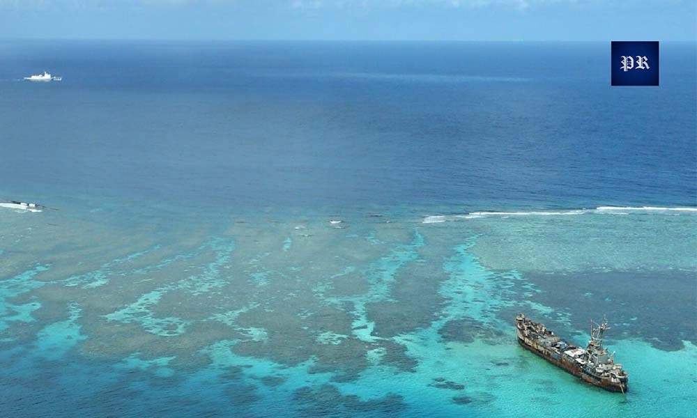
President Ferdinand Marcos Jr. of the Philippines took a decisive stance against China when he assumed office in June 2022, rejecting the more accommodating approach of his predecessor, Rodrigo Duterte. The Second Thomas Shoal, located within the 200-mile Exclusive Economic Zone (EEZ) of the Philippines, has become a focal point of intense conflict between the Philippines and China. To assert its territorial claims in the region, which it refers to as the West Philippine Sea, the Philippines purposefully grounded a ship, the BRP Sierra Madre, in 1999. This vessel has since been a symbol of Philippine presence, with the Philippine Coast Guard conducting monthly resupply missions to support the military personnel stationed on board.
Tensions escalated in 2023 when Chinese Coast Guard vessels began using increasingly aggressive tactics to obstruct Philippine resupply missions. These confrontations have grown more frequent and severe, with incidents involving collisions, water cannon attacks, and the use of military-grade lasers by the Chinese Coast Guard against Philippine ships. These aggressive actions have significantly heightened hostilities in the region.
In response to rising tensions with China, the Philippines has enhanced its alliances with neighboring countries in the Indo-Pacific region including the signing of agreements to expand arms exports, joint military exercises, and base access with the United States. The Mutual Defense Treaty between the United States and the Philippines, reaffirmed by U.S. Secretary of Defense Lloyd Austin in March 2024, ensures that the armed forces, public vessels, and aircraft of both nations operating in the South China Sea are covered under this treaty.
Additionally, Japan has increased its influence in the maritime security domain, supplying military hardware to both Vietnam and the Philippines. This support from Japan is part of a broader effort to strengthen regional security and counterbalance China’s assertive actions in the South China Sea. The Philippines’ strategy under President Marcos highlights a shift towards greater military cooperation and alliance-building to safeguard its territorial integrity and uphold its claims in the disputed waters.
End Note
In summary, the Spratly Islands are claimed in their entirety by China, Taiwan, and Vietnam, while portions are claimed by Malaysia and the Philippines. These overlapping claims have led to significant geopolitical tensions, with various countries establishing military outposts and engaging in diplomatic and legal efforts to assert their sovereignty. The disputes over the Spratly Islands continue to shape the region’s dynamics, influencing international relations and security policies in the South China Sea.